SRRadarLoops Profile Banner
SRRadarLoops Profile
SRRadarLoops

@LoopsSr

5,734
Followers
995
Following
1,632
Media
4,159
Statuses

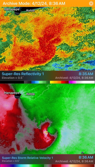
Storm Relative Radar Loops etc

Joined April 2021
Don't wanna be here? Send us removal request.
Pinned Tweet
@LoopsSr
SRRadarLoops
2 years
Overview of the Dec 10th 2021 EF4 tornado including an extensive damage is finally done! Here:
7
33
221
@LoopsSr
SRRadarLoops
2 years
Promise this is the last screenshot from Reed’s video. It’s good to know this matches closely with model simulations.
Tweet media one
Tweet media two
24
281
2K
@LoopsSr
SRRadarLoops
2 years
Disruption of cyclostropic balance will lead to deviations in the vortex orientation within lower-swirl ratio type flows especially when interacting with the axial downdraft.
52
403
2K
@LoopsSr
SRRadarLoops
2 months
Incredible video from Jenny Craighead from Madison IN today. Tornado crossing the Ohio River! Original video in comments #kywx #inwx
19
531
2K
@LoopsSr
SRRadarLoops
1 year
Define Tornado Alley
Tweet media one
55
152
1K
@LoopsSr
SRRadarLoops
1 year
May 3rd 1999 Bridge Creek Oklahoma F5 tornado. The strongest winds ever recorded on earth of 318 mph +/- 20 mph.
Tweet media one
Tweet media two
15
231
945
@LoopsSr
SRRadarLoops
4 months
Large tornado that was on a Beach Cam near PCB
13
220
779
@LoopsSr
SRRadarLoops
1 year
Fridley MN 1986. It wouldn’t surprise me at all if winds were exceeding the speed of sound in brief intervals especially just prior to the vortex breaking down. Note one of these “end wall jets” was intense enough to scour the ground. I dont own this video. Credit: KARE11
35
125
756
@LoopsSr
SRRadarLoops
1 year
Extreme tornado damage from the Purdy TN tornado. Homes destroyed, and asphalt ripped from the roads. Photos: Ethan English
Tweet media one
Tweet media two
28
171
742
@LoopsSr
SRRadarLoops
2 years
Short animation of the 2013 El Reno tornado from RaxPol. Note the "double ring" structure of the eye, and even a debris ejection as the RFD surged and caused the tornado to quickly deviate to the north.
14
132
679
@LoopsSr
SRRadarLoops
2 years
Scour marks from Mayfield closely resembles the Orf simulation. Amazing. Photo from @brianemfinger
Tweet media one
Tweet media two
11
134
651
@LoopsSr
SRRadarLoops
11 months
#SRRadarLoop of an intense MCS that went thru the Tulsa metro area. Likely widespread 80-100 mph straight line winds, and a few embedded QLCS spin ups as well!
7
138
640
@LoopsSr
SRRadarLoops
1 year
Full radar loop of the prolific April 27th 2011 Tornado Outbreak.
20
150
601
@LoopsSr
SRRadarLoops
1 year
#SRRadarLoop Of an ongoing snow MCV? over Lake Michigan.
26
85
546
@LoopsSr
SRRadarLoops
2 years
This appears to be a large storage container. @StephenMWX is from this area and says there’s several of these in the neighborhood the Andover tornado struck earlier. Tremendous upward velocities inside this tornado. Screenshot from Reed Timmer’s video.
Tweet media one
14
97
510
@LoopsSr
SRRadarLoops
1 year
We can’t forget this crazy video of lockers falling out of the sky after the tornado hit Highland East Jr High. Video: MuzikLightzMore
5
92
489
@LoopsSr
SRRadarLoops
5 months
The El Reno EF5 tornado May 24th 2011. An oil rig weighing >800 tons was pulled from the ground, vehicles were shredded, and multiple homes were slabbed along it’s path. RaxPol recorded winds well over 295 mph near this point. Note the multiple debris ejections!
18
87
476
@LoopsSr
SRRadarLoops
1 year
#SRRadarLoop of the 2013 Moore tornado 10 years ago today. This violent tornado tracked for nearly 20 miles, and was rated EF5. Note the many occlusion failures and RFD surges. This is data from OU's MPAR radar.
2
107
460
@LoopsSr
SRRadarLoops
17 days
Tweet media one
8
68
465
@LoopsSr
SRRadarLoops
1 year
#SRRadarLoop of the Joplin EF5 tornado on this day May 22 2011.
6
98
404
@LoopsSr
SRRadarLoops
11 months
Aerial images out of Matador from Dustin Johnson. Virtually every single structure that was in the direct core of the tornado was leveled or slabbed.
Tweet media one
Tweet media two
Tweet media three
Tweet media four
13
99
395
@LoopsSr
SRRadarLoops
1 year
Full #SRRadarLoop of yesterday's highly cyclical and tornadic supercell yesterday in the OKC metro.
1
127
398
@LoopsSr
SRRadarLoops
10 months
#SRRadarLoop of the longer tracked tornado in NC earlier. With a VROT of about 55 kts and a TDS height of 15-20,000 ft ARL this tornado could be in the EF2 to perhaps EF3 range (120-150 mph) pending the storm survey.
10
105
384
@LoopsSr
SRRadarLoops
5 months
The 1995 Pampa Tx F4 tornado: Low level winds were so violent that a 30 ton lane was ripped from its bolts and thrown. Vehicles were lofted and thrown hundreds of yards and industrial buildings were obliterated.
8
57
370
@LoopsSr
SRRadarLoops
1 year
#SRRadarLoop of a tornado near Amory MS earlier. Note the several occlusion attempts and internal momentum surges.
7
120
360
@LoopsSr
SRRadarLoops
1 year
#SRRadarLoop of a strong to violent tornado near Cole OK earlier. With a Vrot of 103 kts and a TDS of 20,000 ft ARL this has a potential of EF3-EF4+ with winds in the 160-180 mph range depending on NWS survey.
10
92
340
@LoopsSr
SRRadarLoops
2 years
It's back. May 3rd 1999 Bridge Creek/Moore F5 tornado. Winds here were well over 210 mph, also note the satellite tornado to the north. Data from DOW.
Tweet media one
6
44
342
@LoopsSr
SRRadarLoops
17 days
Decent tornado on the ground via Kannon Kalton’s stream!
Tweet media one
Tweet media two
Tweet media three
5
74
345
@LoopsSr
SRRadarLoops
1 year
Verification.
Tweet media one
Tweet media two
5
49
332
@LoopsSr
SRRadarLoops
2 years
Iowa State Fairgrounds Camera.
Tweet media one
7
72
322
@LoopsSr
SRRadarLoops
1 year
Tornado on the ground in little rock via Brett Adair! @NWSLittleRock
Tweet media one
Tweet media two
8
121
326
@LoopsSr
SRRadarLoops
2 years
RaxPol data of the Dodge City tornadoes on May 24 2016. Can see the 1st tornado occluding with the new vortex developing to the west. Radar loop of this tomorrow.
Tweet media one
4
26
315
@LoopsSr
SRRadarLoops
2 months
Undocumented tornado July 21 2009. Probably the most LP supercell ive ever seen video of. Link:
Tweet media one
Tweet media two
10
38
319
@LoopsSr
SRRadarLoops
1 year
The LFC is right at the LCL height based on the WoFs sounding. This means both ambient, and baroclinic vorticity gets stretch almost immediately near (or at) ground level. Very high streamwiseness! Photo: @JTmediaOH
Tweet media one
4
55
311
@LoopsSr
SRRadarLoops
11 months
More than likely violent tornado damage from Matador TX earlier. Significant ground scouring + heavy debarking of tornado resistant vegetation is not easy to do in Texas. Very high confidence that in a EF3+ rating per NWS rating. Photos: LSM/Val Castor
Tweet media one
Tweet media two
Tweet media three
Tweet media four
7
82
294
@LoopsSr
SRRadarLoops
1 year
#SRRadarLoop of the cyclical supercell in Tennessee. Note the "loop" the first tornado made before the second tornado that hit Covington TN. Both of these had violent potential
3
73
280
@LoopsSr
SRRadarLoops
2 years
1. On April 27th 2011 the most violent tornado outbreak in American history since April 3rd 1974 took place across the south, up into the mid atlantic. 216 tornadoes took place on that day, with several rated EF4 to EF5.
Tweet media one
2
68
278
@LoopsSr
SRRadarLoops
17 days
multi vortex tornado now near Salem IA via Brett Adair
Tweet media one
Tweet media two
Tweet media three
1
63
286
@LoopsSr
SRRadarLoops
21 days
Pretty sure this is one of the strongest couplets ever off the coast of Hawaii earlier this morning.
Tweet media one
6
37
281
@LoopsSr
SRRadarLoops
2 years
Extensive tree and ground scouring, as well as entire homes completely swept away in the Princeston and Dawson Springs area. Even some pavement scouring. High-res satellite data.
Tweet media one
Tweet media two
Tweet media three
Tweet media four
4
73
272
@LoopsSr
SRRadarLoops
2 years
#SRRadarloop of the 2016 Dodge City KS EF2 tornado on RaxPol. This tornado was more than likely violent, with winds at one point exceeding 120 m/s (270 mph). This tornado's forward speed ranged from around 30 mph to nearly stationary at times.
8
41
268
@LoopsSr
SRRadarLoops
2 years
RaxPol data from the Sulphur OK EF3 tornado in 2016. Such a huge circulation that was over a mile wide, and winds approaching or exceeding 200 mph.
Tweet media one
4
44
270
@LoopsSr
SRRadarLoops
2 years
Tornado on the ground near Huntsville per ARMOR radar. Photo from @DualDoppler
Tweet media one
7
49
261
@LoopsSr
SRRadarLoops
1 year
Today we remember the deadly Greensburg EF5 tornado #Otd 5/4/07. 11 people were killed in Greensburg, and 95% of the town was completely destroyed. Photo: Dan Robinson Please check out the paper by Robin Tanamachi (link below) on the UMASS Xpol dataset of this tornado.
Tweet media one
Tweet media two
3
59
258
@LoopsSr
SRRadarLoops
11 months
A few more photos from the HCTR and LSM in Matador Tx: #TxWx • Vehicles thrown some destroyed with no recognition • Near or complete debarking of Mesquite Trees (very tough trees) • Structures such as restaurants & homes leveled or completely swept bare
Tweet media one
Tweet media two
Tweet media three
Tweet media four
4
69
254
@LoopsSr
SRRadarLoops
1 year
The Cole Oklahoma EF3 tornado as seen by the terminal radar (TOKC). Note the LRE (eye) as the tornado became quasi-stationary SW of town. The new LLMC of the Etowah tornado can also be seen just west of Washington.
Tweet media one
2
44
255
@LoopsSr
SRRadarLoops
2 years
Absolutely some of the best coverage of this thing. @WPSDLocal6 @trentokerson @NbergWX (among others) definitely saved lives.
5
31
251
@LoopsSr
SRRadarLoops
2 years
Likely strong to violent in TX, Vrot of nearly 90 kts
Tweet media one
3
30
248
@LoopsSr
SRRadarLoops
11 months
#SRRadarLoop of the Jarrell TX F5 tornado and associated supercell that happened on this day in 1997. A complicated evolution involving multiple boundaries, extreme buoyancy, and cell mergers made this one of the most extreme tornadic events ever.
7
58
244
@LoopsSr
SRRadarLoops
1 year
#SRRadarLoop of an intense/cyclic supercell that produced a strong to potentially violent tornado in Nebraska. Note the several mergers/RFD occlusions during its life.
2
57
243
@LoopsSr
SRRadarLoops
2 years
@ReedTimmerUSA
Reed Timmer, PhD
2 years
Going through this 4K drone footage reveals complex vortex structure with multiple vortex breakdowns and quick formation of jet like vortices below reservoir of negative pressure perturbation. Sadly, immense damage was caused by this compact tornado
240
2K
8K
0
42
237
@LoopsSr
SRRadarLoops
8 months
24hr loop of Hurricane Lee’s rapid intensification process.
3
59
232
@LoopsSr
SRRadarLoops
2 years
Post pop exposure with NRI data from NOAA. The “gaps” are areas that didn’t have as much population or were rivers. This increases confidence that it may of been a single long tracked tornado.
Tweet media one
6
72
233
@LoopsSr
SRRadarLoops
2 years
Cannot believe it’s been 9 years. RIP Tim, Paul, Carl and Richard.
@LoopsSr
SRRadarLoops
2 years
Short animation of the 2013 El Reno tornado from RaxPol. Note the "double ring" structure of the eye, and even a debris ejection as the RFD surged and caused the tornado to quickly deviate to the north.
14
132
679
3
28
227
@LoopsSr
SRRadarLoops
2 years
The entire 2013 El Reno supercell seen from the RaxPol. Note the huge mesocyclone, the tornado-cyclone and the tornado it’s self. Also several satellite circulations.
Tweet media one
2
46
218
@LoopsSr
SRRadarLoops
1 year
One of the largest/most intense debris fall outs ive seen in a long time.
Tweet media one
6
50
220
@LoopsSr
SRRadarLoops
2 years
3 tornadoes from 1 supercell from the Dodge City tornado outbreak 5/24/16. This is data from RaxPol. The furthest West one was anticyclonic, and the "eye" of both the anticyclonic tornado and main tornado can be seen.
Tweet media one
1
22
210
@LoopsSr
SRRadarLoops
2 years
A look at the May 9th 2016 Sulphur Oklahoma EF3 tornado from RaxPol, and visually. Screenshot from KWTV in OKC.
Tweet media one
Tweet media two
5
18
207
@LoopsSr
SRRadarLoops
2 years
Likely one of the strongest Vrots on WSR-88D at the time of the slabbed home. The red dot is where the house was located near Bremen. 132 kt Vrot with a 264 kt D/V (303 mph). NWS will determine if this is EF5 damage in the coming days.
Tweet media one
Tweet media two
8
57
208
@LoopsSr
SRRadarLoops
3 years
Rare image of the Apison TN high-end EF4 tornado from April 27 2011
Tweet media one
11
25
207
@LoopsSr
SRRadarLoops
2 years
#SRRadarloop of the 2009 Goshen County Wy tornado from DOW5. Notice the "double ring" structure. Peak winds were 60-70 m/s (140-160 mph) at the lowest elevation tilt.
8
32
208
@LoopsSr
SRRadarLoops
2 years
#SRRadarLoop of #Hinnamnor although it's officially 135 kts (155 mph) the winds on radar a few thousand feet up are 165+ mph.
2
47
208
@LoopsSr
SRRadarLoops
2 years
#SRRadarloop of the May 9th 2016 Sulphur Ok EF3 tornado from Raxpol. This is the 2.0° tilt because it's the least messy. However, the 0.0° tilt showed a max velocity of 105 m/s (236 mph) meaning that this tornado was likely stronger than rated. @MikeMorganKFOR
12
44
200
@LoopsSr
SRRadarLoops
2 years
The 2012 West Liberty Kentucky tornado as it developed in Menifee County. Terrain influences enhanced the tornado’s genesis and intensification.
4
22
199
@LoopsSr
SRRadarLoops
2 years
2011 Joplin EF5 simulated by WRF.
3
44
200
@LoopsSr
SRRadarLoops
9 months
Multiple vortex mesocyclone (MVMC) on going with the tornadic supercell in IL!
Tweet media one
Tweet media two
3
41
197
@LoopsSr
SRRadarLoops
1 year
The tornado that hit the town of Covington TN had a vrot of 87 kts and a TDS height of around 22,000ft. This suggest it may of been in the EF4 range with winds of around 170 mph. NWS Survey will have the final say.
Tweet media one
Tweet media two
Tweet media three
Tweet media four
2
43
198
@LoopsSr
SRRadarLoops
1 year
Live reaction of @ReedTimmerAccu intercept earlier.
20
29
194
@LoopsSr
SRRadarLoops
1 year
The long tracked tornado in AL looked similar to the Henryville IN EF4 & the West Liberty Ky EF3 both 3/2/12. I assume relatively high Td’s + high shear produce very sculpted tornadoes.
Tweet media one
Tweet media two
Tweet media three
Tweet media four
2
40
192
@LoopsSr
SRRadarLoops
1 year
VAD Hodographs from 3 extremely violent tornadoes from April 27th 2011. 1.) Philidelphia MS EF5 2.) Hackleburg AL EF5 3.) Tuscaloosa AL EF4
Tweet media one
Tweet media two
Tweet media three
6
32
190
@LoopsSr
SRRadarLoops
11 months
#SRRadarLoop of a damaging tornado near Bancroft GA earlier. With a TDS height of 18,000ft and Vrot of 70kts supports an EF3+ tornado. NWS will survey and determine the rating.
1
42
189
@LoopsSr
SRRadarLoops
2 years
Short radar animation of the June 5th 2009 Goshen Co WY tornado. Peak winds here were in the 150-160 mph range. Note the double ring structure!
6
29
186
@LoopsSr
SRRadarLoops
2 years
First 2 photos are ground scours from the 2011 Philadelphia MS EF5 tornado. Last 2 are from the Mayfield Ky EF4 from Dec 10th 2021. Photos from NWS Jackson MS and @brianemfinger
Tweet media one
Tweet media two
Tweet media three
Tweet media four
9
32
188
@LoopsSr
SRRadarLoops
1 year
Cracked.
Tweet media one
1
38
185
@LoopsSr
SRRadarLoops
1 month
The Rolling Fork supercell about 3 min prior to producing the tornado as seen from the mobile C-Band radar during perils. A lot going on: internal surges, cell mergers, extreme LLMC intensity. It would not surprise me if updraft winds just a few m AGL exceeded 90 m/s!
Tweet media one
5
19
186
@LoopsSr
SRRadarLoops
1 year
#SRRadarLoop of this monster HP supercell in central Texas. Note the vortex hole!
1
42
182
@LoopsSr
SRRadarLoops
1 year
The December 10 2021 WKY EF4 Tornado:
Tweet media one
3
42
181
@LoopsSr
SRRadarLoops
1 year
The tornado that just hit Hosford FL had a TDS of around 14,000ft ARL and a Vrot of 62kts. This puts it within the EF2 to perhaps low EF3 range per NWS survey.
Tweet media one
Tweet media two
Tweet media three
4
34
177
@LoopsSr
SRRadarLoops
2 years
There was a long tracked (likely strong) tornado right in the middle of the 15% tornado risk today. Im not sure how this is a “bust”.
10
14
174
@LoopsSr
SRRadarLoops
2 months
#SRRadarLoop of an intense tornado earlier near Volland KS. This was likely a multi-vortex mesocyclone, given how wide the couplet was on radar. Terrain may of played a role as well.
0
49
176
@LoopsSr
SRRadarLoops
1 year
Rochelle - Fairdale IL tornado April 9th 2015. This extreme violent tornado was rated high end EF4 with winds of ~200 mph, and was likely one of the strongest tornadoes within the last decade.
Tweet media one
Tweet media two
Tweet media three
Tweet media four
6
20
172
@LoopsSr
SRRadarLoops
1 year
Full #SRRadarLoop of last nights long tracked supercell and tornadoes. Prime examples here of Non-occluding mesocyclone genesis, and upscale growth into an intense MCV. Perhaps 3 separate long tracked strong-violent tornadoes from this.
5
56
172
@LoopsSr
SRRadarLoops
1 year
Tiled imagery from the Rolling Fork EF4 from WaldoAirPublisher. 1.) Highly convergent flow as seen from the treefall vectors. 2.) A lot of older homes destroyed next to ones still standing 3.) Horrific damage to mobile homes
Tweet media one
Tweet media two
Tweet media three
3
40
167
@LoopsSr
SRRadarLoops
2 years
The NAM has probably the most classic southern plains hodograph I’ve ever seen for Friday. Like literally textbook.
Tweet media one
10
20
166
@LoopsSr
SRRadarLoops
8 months
#SRRadarloop of the QLCS tornado earlier in MI. With a nearly 70 kt Vrot and TDS height of over 20,000ft this puts it in the EF3+ range per survey.
4
38
168
@LoopsSr
SRRadarLoops
2 months
#SRRadarLoop of the Rolling Fork MS EF4 tornado as seen from the COW radar during PerILs 2023. Note the cell merger & RFD surge. This likely lead to the rapid intensification of the LLMC and rapid tornadogenesis.
5
29
170
@LoopsSr
SRRadarLoops
1 year
Vortex hole associated with the storm near Mayersville MS as seen by COW1. Tornado likely developing now
Tweet media one
1
30
169
@LoopsSr
SRRadarLoops
1 year
The tornado that struck Selma may be at least high-end EF3 based on a vrot of ~75 kts and a TDS height of around 20,000 ft. Nws will have the final say. I certainly expect extensive damage unfortunately.
Tweet media one
Tweet media two
5
45
164
@LoopsSr
SRRadarLoops
1 year
The tornado that just went through southern Magoffin County Ky had a TDS height of about 10,000 ft and a vrot of around 43 kts. This puts it potentially in the EF1 to low EF2 range based on analogs. NWS Jackson will have the final say during the survey.
Tweet media one
Tweet media two
Tweet media three
4
41
168
@LoopsSr
SRRadarLoops
11 months
#SRRadarLoop of yesterday's Matador TX tornadic supercell. Large amounts of sfc vorticity + extreme buoyancy (4000+ j/kg MLCAPE) in addition to a highly streamwise profile lead to even the pre-tornadic cell mergers to acquire strong LLMCs before merging into a giga-supercell
2
38
166
@LoopsSr
SRRadarLoops
2 months
Extreme damage photos of the 1974 Xenia tornado.
Tweet media one
Tweet media two
Tweet media three
Tweet media four
8
25
168
@LoopsSr
SRRadarLoops
2 years
Amazing video from the May 20th 2013 Moore EF5 tornado as it was hitting Highland East. Watch until the end. Video credits: MuzikLightzMore
3
30
161
@LoopsSr
SRRadarLoops
1 year
Wow
Tweet media one
4
16
157
@LoopsSr
SRRadarLoops
2 years
DOW 7 data of the Goshen CO WY tornado from 2009. Will post a loop very shortly.
Tweet media one
3
15
154
@LoopsSr
SRRadarLoops
1 year
Some of the more extreme damage feats from the Rolling Fork EF4 tornado. Extensive granulation of debris, in addition to severe tree debarking. Perhaps most incredibly a power pole snapped about 6ft above ground a caked with loose top soil. All photos from NWS Jackson MS
Tweet media one
Tweet media two
Tweet media three
1
36
158
@LoopsSr
SRRadarLoops
1 year
Tuesday has “high end” potential. The synoptics really remind me of 5/4/03.
Tweet media one
Tweet media two
Tweet media three
Tweet media four
5
30
154
@LoopsSr
SRRadarLoops
2 years
SR Hodographs/CAPE from the April 3 1974 outbreak. Note how the various hodo shapes resulted in different natures of the supercells (cyclical vs steady state).
Tweet media one
Tweet media two
Tweet media three
Tweet media four
8
21
150
@LoopsSr
SRRadarLoops
1 year
18z obs sounding from Dallas... wow
Tweet media one
11
28
156
@LoopsSr
SRRadarLoops
2 years
RaxPol data of the large EF3 tornado on May 9th 2016 near Sulphur Oklahoma. Note the double eye structure of the tornado and the mesocyclone surrounding it. A radar loop of this will be posted soon. Incredible data set.
Tweet media one
5
18
152
@LoopsSr
SRRadarLoops
2 months
Classic example of “wind channeling” from the tornado earlier today on the KY/IN border. Terrain absolutely can increase the tornado’s intensity. #Kywx #Inwx Photo: WLKY
Tweet media one
2
36
158