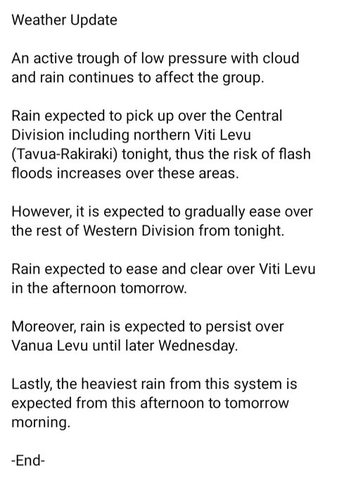
Severe
#TC
Lola now category 5 with max. winds of 205km/hr with gusts of up to 285km/hr. It is heading southwest affecting northern and central Vanuatu.
For more on Vanuatu Advisory, refer to
Our thoughts and prayers are with the people of Vanuatu.
#TCMal
is now likely to intensify into a Category 3 system as it approaches the Fiji Group tonight.
Gale to storm force winds is expected over the land areas of Yasawa & Mamanuca from later this afternoon or evening & spread over the rest of the country overnight.
📌
@FJMETservice
has started receiving impact reports of coastal sea flooding that occurred this morning along Serua, Coral Coast and Lakeba Island in the Lau Group.
Read more:
📽️Sea flooding this morning at the government station on Lakeba Island, Lau.
#TCMal
has intensified into a category 2 system.
#TCMal
is expected to pass close to the west of Fiji tonight with the centre likely to lay approximately 170km west of Nadi at 3am tomorrow morning. It may begin to have an impact on Yasawa & Mamanuca from later today.
TD02F has just been named TC Mal (Cat 1) at 6pm.
#TCMal
was located about 655km West-NorthWest of Rotuma & about 945km NorthWest of Yasawa-I-Rara.
Mal is expected to track to the west of Fiji within the next 24 to 48 hours & approach the group as a category 2 system.
📣MEDIA RELEASE
SEVERE TC KEVIN INTENSIFIED TO CATEGORY 5, ADVERSE WEATHER CONDITIONS EXPECTED TO AFFECT THE FIJI GROUP AS KEVIN TRACKS SOUTHEAST OVER OPEN WATERS
Severe TC Yasa Track Map and Threat Map at midday
Severe TC Yasa was located about 440km west-northwest of Yasawa-i-Rara, about 500km northwest of Nadi & about 395km southwest of Rotuma at midday today. The system is currently moving eastwards at about 6 knots or 11km per hour.
Tropical disturbance, TD02F, intensified into a tropical depression overnight.
It is likely to intensity into a tropical cyclone within the next 24-hours.
It may begin to have an impact on the country from later tomorrow and continue into Wednesday.
TC Yasa Update
At 3⃣am today, 🌀 Yasa has further intensified further into a category 5⃣ system while remaining north-northwest of Yasawa-i-Rara. TC 🌀Yasa is slow moving east-northeast at 4 knots or 6 km/hr. ⬇️The threat map and track map of TC Yasa[cat 5⃣] issued this morning.
📢Media Release
✅Severe
#TCKevin
weakened to a
#CAT4
system around 6am today.
✅
#TC
Kevin has moved further away from Fiji.
✅However, an active trough of low pressure with cloud and rain associated with Severe TC Kevin continues to affect the group.
📢Severe Weather Update
🌀Tropical depression TD03F intensified further into a CAT 1 tropical cyclone at 6am today and named Tropical Cyclone Cody while located to the southwest of Kadavu.
TC Cody is moving towards the southwest and gradually moving away from the Fiji Group.
✅A Gale Alert is now in force for Yasawa, Mamanuca, Western and Northern Viti Levu.
✅Tropical disturbance TD02F could potentially intensity into a tropical cyclone by later Monday or early Tuesday.
🔗Read more:
Koro island is now experiencing gale force winds. As per the graph below it recorded mean wind speed of 83km/hr and gust of 109km/hr at 9pm. It will soon start to experience hurricane force winds.
⚠️A Flood Warning is currently in force for the Wainibuka River and down the main Rewa River.
🚨A Flood Alert remains in force for the Wainimala River and down the main Rewa River.
🔗Follow the link for more information and atest updates:
📣At 12pm today, tropical depression 8F has formed into a tropical cyclone in the Regional Specialized Meteorological Centre (RSMC) –Nadi’s area of responsibility (AoR) near Solomon Islands & named Tropical Cyclone (TC) Judy (category 1).
TC Judy poses no direct threat to Fiji.
📣HEAVY RAIN ALERT.
A Heavy Rain Alert is now in force for Yasawa and Mamanuca groups, northern parts of Ra, Greater Nadi, Lautoka and Ba area, interior of Ba and Nadroga/Navosa, Sigatoka, Kadavu and nearby smaller islands, Lau and Lomaiviti Groups.
At 6am today,
#TCJudy
intensified into a category 2 system while located about 160km east of Vanua Lava or about 430km north off Villa in Vanuatu.
On the current analysis,
#TC
Judy does NOT pose any direct threat to Fiji.
📢Media Release:
Heavy rain & thunderstorm expected from later tomorrow over Northern Division, Yasawa, Mamanuca, Lau & Lomaiviti & gradually spread over the rest of Fiji from Sunday.
A low is also monitored to the northwest of Fiji.
🔗Read more:
🌀TC Irene Intensifies into a Category 2 System
At 6am today, TC Irene intensified into a CAT. 2 system while located to the south of Villa, Vanuatu.
• TC Irene is likely to track over open waters and remain to the southwest of Fiji, about 560km southwest off Kadavu tonight.
Media Release
Tropical cyclone 🌀Yasa rapidly weakened into a category 4⃣ system at 🕰️6am today and further downgraded to a category 3⃣ system at 9am. TC Yasa was located over the Lau Group with the centre near Lakeba at 9am today.
Latest Media Release
Gale force winds with speeds of 65/hr & gusts up to 90km/hr is expected from later this afternoon or evening over Yasawa & Mamanuca & from later this evening or tonight over Western, Northern & Southern Viti Levu, Vatulele, Kadavu & nearby smaller islands.
📢TC Judy Update
#TCJudy
intensified into a category 3 system around midnight last night while located about 212km north of Bauerfield Airport in Vanuatu.
#TCJudy
continues to move south over Vanuatu at about 22km/hr, brining storm force winds and heavy rain over the islands.
📣TC KEVIN UPDATE
Severe
#TCKEVIN
has further intensified into a category 5 system while located over open waters about 720km west-southwest off Nadi at midday today.
🔗Click on the link for more information:
Severe TC Yasa Threat & Track Map at 6am today.
Severe TC Yasa (cat 5) was located about 140km north-northwest of Yasawa-i-Rara, 245 kilometres north northwest of Nadi & 280km west-northwest of Rotuma at 8am today. TC Yasa is moving east-southeast at about 9 knots or 18 km/hr.
📢TC Irene Develops West of Vanuatu
🌀Tropical Depression TD05F developed into a tropical cyclone (category 1) and named TC Irene at 6pm this evening while located to the west of Vanuatu.
TC Irene is expected to move southeast between New Caledonia and southern Vanuatu.
Good Afternoon🙂
☑ A tropical depression 04F is currently monitored in the RSMC-Nadi AoR. TD04F was analysed near Southern Cooks at midday today.
☑ There's is VERY LOW chance of TC development in the Fiji region in the next 5 days.
🌐
⚠️A HURRICANE WARNING REMAINS IN FORCE FOR CONWAY REEF.
⚠️A GALE WARINING REMAINS IN FORCE OPEN WATERS OF FAR SOUTHWEST VITI LEVU, FAR SOUTHERN KORO SEA AND FAR SOUTHERN LAU WATERS.
🔗Click on the link for more information:
📢Severe Weather Update
🌀Tropical disturbance TD03F lies at about 503km west of Nadi or about 453km west of Viwa and moving west-southwest at 11km/hr at 3am today.
For more information:
⚠️River Flood Warning remains in force for low lying areas, small streams & flood prone areas within Tuva, Nadi & Vitogo at Vakabuli, Ba, Nasivi, Yaqara, Penang & Rakiraki River.
🚨River Flood Alert remains in force for low lying & flood prone areas within Sigatoka.
Severe
#TC
Lola further intensified into a
#CAT3
system around 12pm today while located about 250km northeast off Banks Islands (Vanuatu).
Severe
#TC
Lola is expected to affect northern & central Vanuatu. Refer to link for impact advisory on Vanuatu:
📣TC Judy Update
Around 9am today, TC Judy intensified into a
#CAT4
system while located 45km🧭NNE off Vila.
By 3pm today, TC Judy was located 110km🧭NNW off Tanna or about 115km🧭SE off Vila.
TC Judy is expected to have average winds up to 165km/hr with gusts up to 230km/hr
📢Media Release
✅TD03F Has Moderate to High Chance of Developing Into a Tropical Cyclone by Monday
✅Risk of Strong Winds, Continuous Heavy Rain and Severe Flooding
Severe TC Yasa is passing through Yasawa-i-Rara & heading towards Vanua Levu. TC Yasa is expected to make landfall over the province of Bua around 8pm this evening. Close to its centre it is expected to have average winds up to 240 km/hr with momentary gusts to 345 km/hr.
📣FLOOD FORECAST UPDATE
🚨A Flood Alert remains in force for the downstream of Nayavu Station in the Wainibuka River, Nairukurukuru Station in the Wainimala River & main Rewa River from Navolau Village (Naitasiri).
🔗Follow the link for latest updates:
📢Severe Weather Update
🌀Tropical depression TD03F was located about 300km west-southwest of Viwa & 340km west of Nadi at 6am today.
TD03F is moving east towards Fiji at about 15 km per hour.
For more information:
📢Fiji has ENTERED into the Tropical Cyclone Season🌀‼️
✅The Tropical Cyclone Season in Fiji is from 01 November 2021 to 30 April 2022.
#KnowYourWeather
and Be Prepared.
Severe Tropical Cyclone Mal has now been downgraded to a Category 2 system.
TC Mal is expected to continue on a southeast track away from the Fiji Group and weaken as it moves further away.
Severe TC Yasa was located about 50km NNW off Koro & about 60km west off Vanua Balavu at 3am today. Close to its centre the cyclone is expected to have average winds up to 205 km/hr with momentary gusts to 285 km/hr. The cyclone is moving southeast at about 22 km/hr.
📢OFF SEASON TROPICAL DISTURBANCE MONITORED IN THE REGION
A tropical disturbance was analysed last night in our region, to the east-northeast of Solomon Islands & numbered TD01F.
At this point in time TD01F poses no direct threat to the Fiji Group based on the current analysis.
Good Afternoon
For further enquiries regarding earthquakes and tsunamis, please contact the local monitoring agency
@landsfiji
@FijiSeismology
Unit.
☎️3313 555
📧: landsinfo
@govnet
.gov.fj
🌐:
Vinaka.
Source:
@FijiSeismology
📢Latest Update
✅A tropical disturbance has been analysed near Solomon Islands and is expected to drift towards Fiji by early next week.
✅Heavy Rain Alert is current for Northern Division, Yasawa, Mamanuca, Lau and Lomaiviti.
🔗Read more:
📢Severe Weather Update
✅Flash Flood Warning remains in force for low lying & flood prone areas of Vanua Levu, Tavua, Rakiraki, Semo, Nadi, Lautoka, Ba & Tailevu.
✅Flash Flood Alert remain in force for all low lying & flood prone areas from Sigatoka through Coral Coast.
A tropical low that was analysed just to the northwest of New Caledonia has been upgraded to Tropical disturbance TD04F.
TD04F is slow moving and expected to gradually drift southeastwards with low potential of developing into a tropical cyclone in the next 24 to 48 hours.
Expect storm surges around 7pm today(during high tide) along coastal areas of Bua & the northern coastal parts of Vanua Levu (from Nadivakarua, Wainunu Bay, Solevu, Nabouwalu, Votua, Navidamo, Labasa & Udu Point including the islands Yadua, Yaqaga, Kia, Mali & Tavewa).
⚠️A Heavy Rain Warning is now in force for the whole Fiji Group.
🚨A Falsh Flood Alert remains in force for low lying and flash flood prone areas of Viti Levu and is now in force for southern and northeastern Vanua Levu(from Nabouwalu through Kubulau, Savusavu up to Saqani).
Severe
#TCLola
has downgraded to
#CAT3
around 12pm today while located about 40km west off Ambrym (Vanuatu).
TC Lola is currently moving southwest at 12km/hr (6 knots). It is expected to weaken further to
#CAT2
tonight while passing to the west and moving away from Vanuatu.
📣Heavy Rain Alert.
🚨A Heavy Rain Alert is now in force for:
✅Yasawa & Mamanuca groups
✅Nadi, Lautoka, Ba, Tavua, Rakiraki, Interior of Ba & Ra
✅Bua Province
✅Eastern Macuata Province.
Follow the link for more information & latest updates:
⚠️Severe Weather Update
A low pressure system currently lies near Sols. However, this system is not expected to directly affect Fiji.
The only concern for Fiji will be the possibility of heavy rain with risk of flooding from the associated convergence zone later next week.
TC Cody (Cat 1) to the southwest of Viti Levu continues to move west further away from Fiji. Associated active rainbands continue to affect the Western Division.
Meanwhile, an active trough with cloud & rain remains slow moving over the northern and eastern parts of the group.
Tropical disturbance TD03F is currently is located at approximately 188km East-Northeast of Honiara (Solomon Islands).
Heavy rain and strong winds are affecting Santa Isabel island, Malaita island and New Gerogia Islands of Solomon Islands.
Read more:
Around 12pm today,
#TCKevin
upgraded into a
#CAT2
system while located about 410km🧭WNW off Santo in Vanuatu.
TC Kevin is expected to have average winds up to 95km/hr with gusts up to 130km/hr
TC Kevin is currently tracking 🧭ESE at 25km per hour.
Severe Weather Update
As predicted, the centre of Tropical Cyclone Ana(Category 2) is currently moving at 11km/hr over the coast of Viti Levu between Suva and Navua, heading for Kadavu.
Low Pressure System to the Northwest of Fiji Develops Into Tropical Disturbance 09F(TD09F)
Latest public weather bulletin available at:
Latest special weather bulletin on heavy rain available at:
⚠️A Heavy Rain Warning remains in force for:
✅Kadavu
✅Yasawa& Mamanuca groups
✅Greater Sigatoka-Nadi-Lautoka-Ba-Tavua-Rakiraki Area
🚨A Heavy Rain Alert remains in force for the rest of the Fiji Group.
🔗More info➡️
At 6pm today, TC Dovi has intensified into a Cat. 2 system near New Caledonia.
TC Dovi continues to affect New Caledonia with damaging/destructive winds & heavy rain.
Dovi continues to move 🧭SSW to the south of New Caledonia by tomorrow.
Our prayers are with the people of 🇳🇨.
Good morning Fiji.
A DAMAGING HEAVY SWELL event is anticipated over the coastal areas of south west Viti Levu (from Natadola to Coral Coast to Deuba), the southern coastal areas of Beqa, Vatulele and Kadavu especially during high tides for today and tomorrow.
📣A Strong Wind Warning remains in force for the land areas of Yasawa, Mamanuca, Lau, Lomaiviti, Kadavu, Vatulele & nearby smaller islands, coastal areas of Nadroga-Navua-Nasinu-Korovou-Rakiraki and Nabouwalu-Savusavu-Tunuloa-Udu Point, Taveuni & nearby smaller islands.
📢Severe Weather Update
Tropical Depression TD03F was located about 110km south-southwest of Kadavu & 240km south of Nadi at 3am today.
TD03F is moving southeast to the south-southwest of Kadavu at about 20 kilometres per hour.
For more info:
It's heating up across 🇫🇯 as warm💨from the Equator is pushed over the group by the 🧭NE 💨. Max. temp. of 3⃣4⃣.5⃣°C was rec. in Navua & Levuka. 🥵conditions with temp. reaching the low 3⃣0⃣'s will continue to persist until Wed. A normal phenomena during this time of the year.
📢A Strong Wind Warning is now in force for the land areas of:
✅Yasawa Group
✅Kadavu and nearby smaller islands
✅Lau Group
✅Lomaiviti Group
⚠️Strong winds can break trees branches & cause damages to very weak structured houses or unshielded structures in exposed communities.
Severe Weather Update
Warning
⚠️A Heavy Rain Warning remains in force for Vanua Levu, Taveuni and nearby smaller islands, Lau and Lomaiviti Group.
⚠️A Heavy Rain Alert remains in force for the rest of the Fiji Group.
📢Media Release
TROPICAL DISTURBANCE TO THE WEST OF VANUATU POSES NO DIRECT THREAT TO FIJI-
Trough of Low Pressure Expected to Affect Parts of the Group from Tomorrow
For latest updates or clarifications:
📱+679 9905376
☎️+679 6724888
🌐
📣We have just released our Tropical Cyclone Seasonal Outlook for 2022-23.
📍Tropical Cyclone Outlook for Fiji 🇫🇯
From November 2022 to April 2023.
🔗Read more:
Here are the key messages⬇️
Rakiraki is now experiencing gale force winds. It recorded mean wind speed of 40 knots and gust of around 50 knots at 10am. The graph is showing how the wind strength has increased at Ellington, Rakiraki in recent hours in m/s.
Total Lunar Eclipse Sighted Last Night
The supermoon was visible all over the world. Luckily, the full lunar eclipse or blood moon was also visible in Fiji.
Fore more:
Photo Credit:
@Viti_Kid
Update on Severe TC Ana(Category 3)
TC Ana was located about 210km west of Ono-i-Lau or about 110km 🧭SSW of Matuku at 6am today. TC Ana is moving 🧭SSE at about 14km/hr. The associated gale force winds up to 65km/hr and rain is expected to affect Ono-i-Lau and Vatoa
⚠️A Heavy Rain Warning is now in force for Yasawa & Mamanuca, Northern Ra,Tavua,Ba, Lautoka,Nadi, Sigatoka, Interior Nadroga-Navosa, Kadavu & nearby smaller Islands, Lau & Lomaiviti.
🚨A Heavy Rain Alert is now in force for the rest of Fiji.
🔗Red more:
Effective communication of weather forecasts & warnings allow
@FJMETservice
stakeholders & the public to prepare for extreme events.
@FJMETservice
in partnership with
@spc_cps
#GEMDiv
#COSPPac
are developing a number of standard comms. products to support this objective.
Severe Weather Update
⚠️A Strong Wind Warning is now in force for land areas of:
☑️eastern half of Vanua Levu
☑️Taveuni and nearby smaller islands
☑️and the Lau Group.
⭕️Fresh to strong northerly winds with average speed of 50km/hr
⭕️ sway big trees & twigs breaking off trees.
Bula Vinaka🙂
📣This is your updated Weather Outlook in brief for today until Sunday.
🔗For detailed 7- Day Outlook:
🔗For daily Public Forecast Updates:
🔗For daily Marine Forecast Updates:
🌀Severe Weather Update
At 12pm today, TC Ruby has moved out of the RSMC- Nadi Area of Responsibility. Henceforth, the Meteorological Service of New Zealand will be taking over the monitoring & warning responsibilities.
Read more:
🌀2021/2022 Tropical Cyclone Seasonal Outlook
✅1️⃣ to 3️⃣ tropical cyclones likely to pass through Fiji’s (EEZ) during the 2021-22 TC Season
✅1⃣ to 2️⃣ TC's are likely to reach severe category
🌐For detailed 2021/2022 Tropical Cyclone Seasonal Outlook:
📢Severe Weather Update
🌀Tropical disturbance TD03F lies at about 503km west of Nadi or about 453km west of Viwa and moving west-southwest at 11km/hr at 3am today.
For more information: