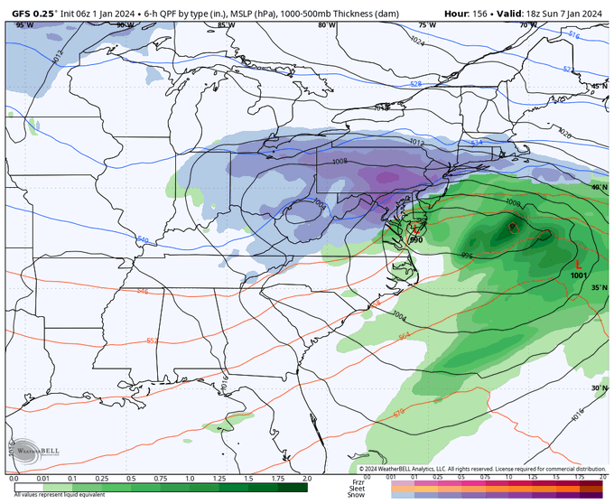
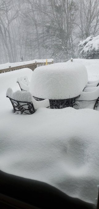
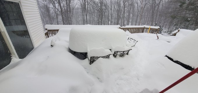
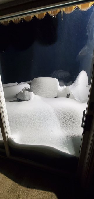
Will Ciccone Profile
Will Ciccone

@weatherwilly

9,435
Followers
677
Following
5,019
Media
24,724
Statuses

Weather Enthusiast

Randolph, NJ
Joined November 2012
Don't wanna be here? Send us removal request.
@weatherwilly
Will Ciccone
5 months
*Major Winter Storm for this weekend continues to gain traction*. There are elements to this that look classic. Stay away from app snow forecasts they change constantly. I will put out a preliminary impact map by tomorrow and estimate regional impacts, Rain/Snow line etc.
Tweet media one
25
19
325
@weatherwilly
Will Ciccone
9 months
Summers over in my book once this beautiful Fall airmass hits Wednesday night...summer dew points gone!
25
21
312
@weatherwilly
Will Ciccone
3 years
Reporting 19" as of 1250pm Randolph NJ Epic
Tweet media one
25
43
291
@weatherwilly
Will Ciccone
1 year
This picture is gold....for snow starved folks along east coast this is the exact pattern you need shown for storm development March 10th on...block is west east orientated, there's a western ridge and perfect 50/50 low...if this verifies my call for winter over in Mid-Atl would
Tweet media one
28
24
267
@weatherwilly
Will Ciccone
6 months
Pattern Update: All in On January Pattern Change 1. I am forecasting a major pattern change for January 2. Evolution starts after Christmas, kicks in by 2nd week of Jan 3. There will be no pushing this off, if its delayed I change whole winter forecast
31
32
257
@weatherwilly
Will Ciccone
3 years
Just broke 2 Feet in Randolph NJ..storm total 25" so far ...all measurements taken using an average of 3 snow boards cleared every 6 hours
Tweet media one
8
44
253
@weatherwilly
Will Ciccone
5 months
Take a look at the two day trend in GFS...this is what I was trying to illustrate the other day, all the energy was sitting there offshore and all it takes is a minor adjustment in upper levels to consolidate and pull the energy towards coast. Models tend to under anticipate
25
14
251
@weatherwilly
Will Ciccone
3 years
Final tally for tonight in Randolph NJ 27.8"...will see how it adds up again early tomorrow morning
Tweet media one
15
30
244
@weatherwilly
Will Ciccone
4 months
Sorry I can't not post 2" an hr plus snowfall rates, now over 6" in Randolph
21
17
243
@weatherwilly
Will Ciccone
5 months
**Morning Update/Forecast** Most realistic scenario I see is low running just off Cape Hatteras to Cape Cod (pic 1). Euro way too suppressed, CMC UKMET models way too inland and act as if arctic front doesn't exist. You don't just shove that kind of air away that quickly(pic
Tweet media one
Tweet media two
Tweet media three
34
23
240
@weatherwilly
Will Ciccone
5 months
**Initial Snowfall Forecast: Friday** Tough one this time with high degree of volatility. Next map update tomorrow am. Map reflects not any particular model, but how I think this evolves/trends. Also factors in snow ratios.
Tweet media one
27
31
241
@weatherwilly
Will Ciccone
8 months
The 2024 Winter Outlook
32
37
228
@weatherwilly
Will Ciccone
2 years
Hope you guys realize how impressive it is to see a normalized anomaly this strong at 350 hours out on an ensemble system, not to mention the negative underneath...buckle up winter is coming and may be sooner than some think
Tweet media one
27
36
218
@weatherwilly
Will Ciccone
5 months
The pattern change is on track and has staying power based on my current observations. Got to love the block over Greenland. It's about time we get a flip in the pattern during the core of winter and not in March! Low sun angle and fluffier snow!
Tweet media one
20
18
212
@weatherwilly
Will Ciccone
5 months
All the major weather models are now sniffing out the Jan 7th winter storm threat. In the coming days expect a lot of shifts in the projected storm track, including misses. I will keep you in the loop on what I think is most realistic and where potential impacts will be.
Tweet media one
Tweet media two
Tweet media three
31
26
210
@weatherwilly
Will Ciccone
5 months
Here's the good news, by Valentine's Day you see the pattern start to shift to a typical late season El nino look... High pressure now over Alaska with low pressure to the south of the Aleutians Is a classic signal for a flip back to wintery conditions in the east.
Tweet media one
21
23
199
@weatherwilly
Will Ciccone
1 year
300ft Morristown NJ vs 1000ft Randolph only 2.5 miles away
Tweet media one
Tweet media two
13
11
203
@weatherwilly
Will Ciccone
1 year
Winter is an awful season when it's mild and in 40s most days with high lows at night... I don't know how people down south think this is good... Give me 25° with a snow pack or give me Summer
27
6
195
@weatherwilly
Will Ciccone
3 months
There is literally no cold in sight for the entire eastern 1/3 first 10 days of March. Records will be broken in spots. This will verify, it fits what's happened all season. Let's hope ski country can recover in the period after this! Very depressing
32
17
196
@weatherwilly
Will Ciccone
1 year
Winters return on track for end of Jan to Feb on major models (pic 1)...initial response at 18k ft then cold air follows by end of Jan (Will Take Time)..this time, unlike Dec, it is backed by consistent trends in tropics (pic 2) and a decent shot of elongated Polar Vortex (pic3)
Tweet media one
Tweet media two
Tweet media three
24
29
194
@weatherwilly
Will Ciccone
4 months
Here's a tidbit. Last 3 El Nino seasons that had the MJO going into phase 8 in Feb vs Euro model from Feb 14th on. This winter flip could run to March 14th. There comes a time to move from middle and make a forecast. Bookmark this tweet. I am all in. We will judge at the end.
Tweet media one
Tweet media two
19
31
189
@weatherwilly
Will Ciccone
4 months
Just downright insane to open March...could hit 50s in northern VT... disgusting
Tweet media one
44
10
190
@weatherwilly
Will Ciccone
5 months
1 inch or 30" still have to enjoy it guys
Tweet media one
15
4
187
@weatherwilly
Will Ciccone
4 months
A little season end rant. Sometimes you need to know when to hang it up. Wildcard late season snowstorms and ski country snows (they prob do fine 2nd half of March) is not the same as a flip back to winter for most of the eastern population.
47
19
186
@weatherwilly
Will Ciccone
4 months
**Update** Major Winter Storm Big changes overnight with the evolution of the storm. I was not correct with thinking this would stay more north. The observations and data are now supporting a major snowfall further south. My new map is below. Will have commentary later.
Tweet media one
29
23
184
@weatherwilly
Will Ciccone
9 months
Goodbye summer
Tweet media one
16
11
184
@weatherwilly
Will Ciccone
5 months
***Initial Snowfall Forecast: Mon Night-Tuesday** Trends last 24 hours have supported the going idea that the trailing storm energy can amplify more than originally shown. I am going with the idea of a moderate snow event for many Tuesday. In particular, I think parts of New
Tweet media one
15
22
177
@weatherwilly
Will Ciccone
5 months
Holiday Video Update: Hunting for Snow 1. Pattern change kicks in post NYE (0:22) 2. Winter storm potential ~ Jan 7th along East Coast (1:20) 3. Pattern change may have staying power (2:40)
13
26
166
@weatherwilly
Will Ciccone
1 year
Most bullish signal I have seen this season...ensemble models show a pattern (pic 1) that could support east coast storm ~13th...unlike recent events, projected migration of t storms in tropics support the west ridge/east trough projections are showing (mjo phase 8, pic2)
Tweet media one
Tweet media two
19
24
169
@weatherwilly
Will Ciccone
1 year
New data coming in, going to be an old fashioned snowstorm in NNJ into Southern New England tonight...just like the ones we used to know...snow will be very heavy at times by late tonight with snowfall rates 1" per hour in places
Tweet media one
16
10
164
@weatherwilly
Will Ciccone
6 months
GFS ensemble now trending towards Euro and agrees with its own MJO progression... My Forecast: A true pattern change starts last few days of the year..will take about two weeks from there to fully settle in and see wintery weather near big cities
12
9
161
@weatherwilly
Will Ciccone
8 months
2024 Winter Outlook Maps... For those who want the finer details the video discussion is in an earlier tweet linked below:
Tweet media one
Tweet media two
Tweet media three
@weatherwilly
Will Ciccone
8 months
The 2024 Winter Outlook
32
37
228
18
10
158
@weatherwilly
Will Ciccone
6 months
Major pattern change (cold) continues to be on track for turn of the year and can have staying power. My attention is on the end of the 1st week of Jan for potential winter storm development, ingredients I like to see just staring to get "sniffed out" on long range models
Tweet media one
17
24
155
@weatherwilly
Will Ciccone
4 months
I am still watching this period around Presidents Day weekend. Could see low pressure development off coast focusing on N Mid Atl to New England. Rough sketch below with key variables outlined.
Tweet media one
18
20
159
@weatherwilly
Will Ciccone
5 months
S+ snow! 2" hr Randolph New Jersey..4.5" and piling up fast!! Main event is here! Cold air winning areas like northeastern New Jersey keep an eye on the radar.
11
19
156
@weatherwilly
Will Ciccone
5 months
*My First Speculation on Next Week's Storm* In the video below I speculate on how I think storm next week evolves. Overall, I am favoring a more amplified storm into arctic air. This means I think many areas (big cities included) have a shot at a major winter storm.
15
21
154
@weatherwilly
Will Ciccone
5 months
By the way guys, I am a straight shooter even though I am saying I still think we can see snow on Tuesday it's not a major storm, originally I thought this could be bigger...not going to move goal posts like some do
Tweet media one
40
10
152
@weatherwilly
Will Ciccone
1 year
Colder than normal temperatures continue into May... We torched all winter, and then right on cue, a cold spring prevails... Did you expect anything different?
Tweet media one
24
20
148
@weatherwilly
Will Ciccone
2 years
Twitter gets really quiet when most folks don't expect much snow in their backyard...the true weather enthusiasts stay on...got to appreciate the meteorology of this storm
19
5
151
@weatherwilly
Will Ciccone
4 months
Randolph NJ now at 10.3" Board was cleared one time at 7:00 a.m. 4.5" plus 5.8" after it was cleared Snowfall rates last two hours over 2"/hr Stay tuned for final total @NWS_MountHolly
Tweet media one
19
14
149
@weatherwilly
Will Ciccone
1 year
*6pm Storm Update* I am sticking by my colder forecast for this storm that I put out this morning. The video below explains why. As of now I am expecting wintery impacts by tomorrow afternoon for anyone in dark pink zone to the NW. Final update in the AM with any changes
15
12
148
@weatherwilly
Will Ciccone
4 months
Here is my initial forecast for Friday night into Saturday morning's clipper system.
Tweet media one
16
13
145
@weatherwilly
Will Ciccone
3 years
We haven't had a good winters in years and already I hear so much "can't wait for spring, enough with this snow" snow lovers are a rare breed...how can you not love snow...it's nature's gift and completely transforms a landscape to a peaceful place
20
9
139
@weatherwilly
Will Ciccone
4 months
New GFS rolling in. Alot of focus has been on speed of this storm but the strength is what is impressing me the most. Unlike other storms this year with marginal warm air, the strength of this system is going to cause a rapid changeover to heavy snow once off coast w/ wind shift
Tweet media one
Tweet media two
22
11
144
@weatherwilly
Will Ciccone
4 months
**Final Forecast** I am more north than some, I know. Well see how it plays out. Fun little system to track overnight.
Tweet media one
13
16
144
@weatherwilly
Will Ciccone
5 months
For you other weather enthusiasts out there, I hope you all realize how ridiculous a look this is on an ensemble. Big time west based NAO with direct discharge of arctic air and part of the PV sitting eastern Canada..this doesn't happen often...
Tweet media one
Tweet media two
11
18
138
@weatherwilly
Will Ciccone
1 year
Winter weather lovers we might be at Rock bottom, but just above rock bottom is at least having something to look at on a 240 hour long-range model... I will not discuss this unless I actually see more support for it but it's better than having nothing to look at
Tweet media one
37
7
138
@weatherwilly
Will Ciccone
5 months
I was falling asleep on the couch and the new NAM model literally just woke me up ...what a run, it really tightens up the energy off the Coast vs before, allowing a stronger system..may be model run of the year
Tweet media one
Tweet media two
14
9
142
@weatherwilly
Will Ciccone
5 months
The storm that is going to develop in the country middle of next week is going to be extremely impressive. Do not be so fast to just think this cuts into lakes. There is a block in place and focus on region in pic 1. If this area presses south more(would create stronger high
Tweet media one
Tweet media two
26
23
137
@weatherwilly
Will Ciccone
5 months
**Winter Storm on Track for Saturday Night-Sunday** Here is my first estimate of impacts. NW of I-95 should see the worst impacts. This will get updated daily with more detail especially as it relates to higher end of snow totals. Stay tuned for more analysis later today.
Tweet media one
26
19
140
@weatherwilly
Will Ciccone
5 months
Still watching next weekend as well guys... Nothing better than tracking two storms threats at once! Very rare
Tweet media one
12
10
139
@weatherwilly
Will Ciccone
1 year
90 hour GFS ensemble starting the squeeze on 10mb Polar Vortex. Nice to see this inside 100 hrs vs a 300hr projection...if this continues it will help support the case for late Jan to Feb we have been discussing
Tweet media one
8
17
139
@weatherwilly
Will Ciccone
4 months
What's interesting about Saturday is usually when you have a block in place like this with established cold air and west ridge, these things will want to amplify a little bit more under it... I wouldn't be surprised to see this trend north because of this
Tweet media one
Tweet media two
11
12
140
@weatherwilly
Will Ciccone
2 months
My best shot from today's eclipse in New Jersey
Tweet media one
8
2
140
@weatherwilly
Will Ciccone
1 year
Completely burried 17"...my rental cabin at 1000ft behind the village of Stowe Vermont... Just 100 or 200 ft below has much less snow
11
8
136
@weatherwilly
Will Ciccone
6 months
This is not In any way a forecast, I'm showing this because it's really cool to see long range GFS model produce the setup for a textbook Northeast winter storm... pretty much every ingredient is on this map you would read about in the Kocin textbook
Tweet media one
Tweet media two
Tweet media three
Tweet media four
11
16
138
@weatherwilly
Will Ciccone
5 months
Shes a big one
Tweet media one
13
10
136
@weatherwilly
Will Ciccone
5 months
February can come in like a lamb out like a lion... key is flip over Alaska with high pressure returning along with low to the south...the nino analogs and strat warm back this up as does recent climatology
Tweet media one
Tweet media two
9
24
135
@weatherwilly
Will Ciccone
4 months
**Preliminary Storm Outlook** Below is my first estimate of impacts from Mon night-Tues. I do not go too high this far out. Storm will not have a lot of cold air & 10:1 maps are misleading near coasts. Storm however could be quite strong which can help cool column into SNE
Tweet media one
24
18
137
@weatherwilly
Will Ciccone
5 months
Below is why I refuse waffle with long-term and ultra long term model runs... As I said yesterday we have a really good winter pattern coming up that can include a major storm by end of week 1 of Jan.. It's supported by current observations and shorter term projections that could
9
14
132
@weatherwilly
Will Ciccone
5 months
*Let's Take an Updated Look at Next Week's Winter Storm Potential* Some Updated Speculation... Pattern Has the Signature: 0:20 Pressure Pattern, Banana High?: 1:10 Areas That May See Snow: 2:00 Risks to Watch for Big Cities: 2:38
11
14
134
@weatherwilly
Will Ciccone
1 year
I continue to see no signs of anything in the weather pattern to provide snow over the next few weeks this may go down as one of the worst winters on record for some
32
3
131
@weatherwilly
Will Ciccone
5 months
**First Estimate Snowfall Forecast: Sat Night-Sunday** Kept the shading very consistent from yesterday's preliminary map. Added in a first look at snowfall accumulation ranges. This is my forecast and not necessary based on any one model. Stay tuned for updates!
Tweet media one
32
11
133
@weatherwilly
Will Ciccone
1 year
On vacation this week but a glacier is about to build over interior New Eng next 7 days with then the shot for snow further towards coast to follow...we got winter back in the east for at least next 2 weeks...stay tuned and polish up your skis
Tweet media one
22
21
132
@weatherwilly
Will Ciccone
4 months
Here is the start of the expected pattern change end of week two of February...looks like a storm signature on long range ensembles towards presidents day weekend. Let's keep an eye on this.
17
19
134
@weatherwilly
Will Ciccone
4 months
This is a storm signal for around Valentine's Day to kick things off in Northeast...ensemble continues to show confidence in energy ejecting out of southwest and consolidating in the east under a developing block and building western ridge
18
18
134
@weatherwilly
Will Ciccone
5 months
And per last tweet now we are sitting at a point where this is a respectable storm system! Forget the weather apps.
Tweet media one
Tweet media two
12
7
132
@weatherwilly
Will Ciccone
5 months
A storm like this is 8 to 14" type event, locally higher My first map stays conservative.. every 24hr update I then hone in on more detailed accumulation ranges with hopefully not having to change the shaded zones much. That's my process starting 5 days out.
Tweet media one
19
15
132
@weatherwilly
Will Ciccone
6 months
There should be a strong cold shot into the United States after turn of the year...air source changes from pacific to arctic with big Canadian high pressure migrating south into USA....this is an ensemble average so verification would be much colder .. #patternchange
Tweet media one
Tweet media two
Tweet media three
8
16
130
@weatherwilly
Will Ciccone
5 months
This is so close for Friday...classic ingredients still there its just a little too progressive right now. Ridge needs to trend stronger(boxed area) and then energy will consolidate more into the slot on east coast. Within margin of error on models. Lets wait and see.
Tweet media one
11
11
129
@weatherwilly
Will Ciccone
5 months
**Update on Friday's Moderate Snow Chances** I took a long look at this today and I like the idea of a moderate snow threat for some folks in the Mid-Atlantic Friday. I break down what is driving this and what could change in the video.
15
14
132
@weatherwilly
Will Ciccone
1 year
This weather pattern is about to really pop folks...buckle up... video coming tonight
11
7
131
@weatherwilly
Will Ciccone
4 months
Every storm is a challenge but I have actually never seen this much model volatility inside 24 hours. I've seen models shift as storm is approaching causing a bust but this has been a complete rodeo 24 hours out. I certainty fell off the bull.
17
6
130
@weatherwilly
Will Ciccone
4 months
Results are in! As I always do...Final Forecast vs Actual
Tweet media one
Tweet media two
30
11
128
@weatherwilly
Will Ciccone
4 months
If you want to see some of the best snow in the world you go to Alta... Barely can even get into my condo
Tweet media one
17
9
131
@weatherwilly
Will Ciccone
4 months
Continue to really like what I see for major pattern flip Feb 14th on, maybe even a storm near Pres Day. Before this, it stays seasonable to mild. Yes southern storm chance next week but I think flow stays too fast (could be wrong). Still think its being rushed.
Tweet media one
Tweet media two
Tweet media three
15
19
127
@weatherwilly
Will Ciccone
6 months
Sunday Pattern Update: 1. No question pacific jet will dominate at least till Christmas 2. This means milder air takes over by end of next week (mjo7) 3. My original idea of a flip by 2nd half of December was wrong 4. Now we focus on Christmas to NYE if MJO gets to 8/1
36
13
126
@weatherwilly
Will Ciccone
5 months
If we can pull this storm off next week, it will be the first time in a while we would have snow on the ground that could stick around with below normal temps and low sun angle
Tweet media one
Tweet media two
16
5
125
@weatherwilly
Will Ciccone
6 months
Transition to Snow Randolph NJ...32 degrees
18
13
122
@weatherwilly
Will Ciccone
5 months
**Updated snowfall forecast for this weekend's storm** Starting to now add more detail as we are approaching 48 hours. Stay tuned for updates later.
Tweet media one
18
16
127
@weatherwilly
Will Ciccone
5 months
Not much to add tonight guys. I like the idea from this morning and looking forward to tonight's model data. Will make a final forecast tomorrow am. In reality, inverted trough situations like this can shift up to the point the event is actually occurring. Fun times ahead.
Tweet media one
11
13
124
@weatherwilly
Will Ciccone
5 months
**Forecast Update** Some great trends last 24 hours with delivery of cold air for Sunday's winter storm threat. Even though this still isn't an ideal setup near coasts, it can support rain changing to snow with heavier snow to the northwest. This also is an elevation dependent
Tweet media one
18
15
125
@weatherwilly
Will Ciccone
3 months
Yesterday morning might have been one of the best ski days of the year for the East Coast.. I was fortunate enough to be able to go out for a few hours at Stowe here's some footage from National Trail
17
5
126
@weatherwilly
Will Ciccone
6 months
The GFS and it's ensembles are starting to flirt with a "follower low" idea after initial rain moves through late next week...a follower low means a low can develop into cold air in the wake of 1st storm by amplifying mean trough (blue region consolidating)... I'll be watching
10
15
119
@weatherwilly
Will Ciccone
5 months
Why do I continue to beat a dead horse about ~ Jan7th? Because its the first time all winter we have seen a true block (pic 1 highlighted) that can lock in a cold high ahead of the storm. Rather see this stay south and trend north. The Jan 4th storm is progressive and a wildcard
Tweet media one
Tweet media two
Tweet media three
Tweet media four
16
17
122
@weatherwilly
Will Ciccone
5 months
For you weather nuts out there...I think Kocin would like this evolution for next weekend. Right out of the textbook.
15
17
123
@weatherwilly
Will Ciccone
5 months
New Nam and also UKMET starting to sniff out what I'm expecting happens with this system by amplifying that trailing energy more ...just models, does not mean I end up being right. Well see how it looks by tomorrow afternoon.
Tweet media one
Tweet media two
Tweet media three
14
13
122
@weatherwilly
Will Ciccone
5 months
**Morning Update/Updated Forecast Thoughts** This may surprise or even agitate some, but I am not throwing in the towel yet on Tues/Wed snow chances. Below I will explain my updated thoughts: Recent trends have gone very flat with the lead storm energy in pic 1 due to western
Tweet media one
Tweet media two
Tweet media three
18
16
122
@weatherwilly
Will Ciccone
7 months
One thing I will said with high confidence is bundle up for Thanksgiving this year, in the wake of Wed storm coldest air of season arrives...highs in 30s...this is my official arrival of Winter 2024
Tweet media one
Tweet media two
Tweet media three
4
11
124
@weatherwilly
Will Ciccone
1 year
Seriously guys its time to pack it in, everyone who has followed me for 10 plus years knows I love cold and snow and dont say this often
30
2
123
@weatherwilly
Will Ciccone
7 months
*Speculation* The period to watch for a more regionwide snowfall would be early the week after Thanksgiving, there will potentially be a healthy cold air boundary in place a storm can develop along...looks similar to Dec 5 2002 (bias more north).. see my video last night
Tweet media one
Tweet media two
Tweet media three
9
16
120
@weatherwilly
Will Ciccone
5 months
**Pattern Update: Major High Impact Rain Storm then All Eyes on the 17th** Intro: 0:01 Major Rain/Wind Storm this week: 1:16 Snowmaker for some this weekend as far south as NW Mid Atl: 2:17 Major storm signal ~ Jan 18th with deep cold in place: 3:00 Mild Risks Late Jan: 4:39
13
15
117
@weatherwilly
Will Ciccone
6 months
The exact evolution we need to see to break this pacific pattern...ridge getting pulled back into western Canada.....GFS isn't as enthusiastic vs European seen below but IF MJO does strong rotation into phase 1 this will likely verify last few days of the year with appropriate
7
16
120
@weatherwilly
Will Ciccone
1 year
There is major potential on the table for end of this week.. European has been leading the charge handling the pattern )...Im very bullish...below are my thoughts on potential winter storm, still speculative but I see all the variables in place
5
11
120
@weatherwilly
Will Ciccone
5 months
We are underway... Temperature 20.5 dew point 15... Randolph NJ
12
7
119
@weatherwilly
Will Ciccone
1 year
Before everyone screams at me for posting 384 ensemble means my point is still the same...as warm as it is now, we have had many warm winters where we saw no hope on long range ensembles, so putting this it in perspective...game is not over
Tweet media one
Tweet media two
Tweet media three
22
8
117
@weatherwilly
Will Ciccone
5 months
This is a beautiful run of the NAM model coming in...storm looks much more organized at all levels of the atmosphere. Increases chances for bonus backend snow Sunday as low pressure is reinforced by trailing shortwave. Love seeing this
Tweet media one
Tweet media two
Tweet media three
Tweet media four
17
15
116
@weatherwilly
Will Ciccone
1 year
1/1 Good Morning, Here is my initial estimate for Thurs-Fri storm impacts...will hone in on more details over next 24 hours...Old fashioned snowstorm for the interior with front end snow to mixing in pink zone and plain rain to the south...in terms of models....
Tweet media one
24
13
116
@weatherwilly
Will Ciccone
1 year
As of now I like the idea of a miller B storm for end of next week on the heals of a nice cold shot early in the week...another New England special... Models will be all over to place but there's good signature on the ensembles... I'll keep an eye on it
Tweet media one
Tweet media two
20
8
116
@weatherwilly
Will Ciccone
2 years
This is one of best euro ensemble forecast loops (dec 10th to 14th) ive ever seen...i really couldn't draw it up better myself for a winter pattern in the Northeast..in fact, this looks so good that now Im looking for what can go wrong...stay tuned
15
12
117