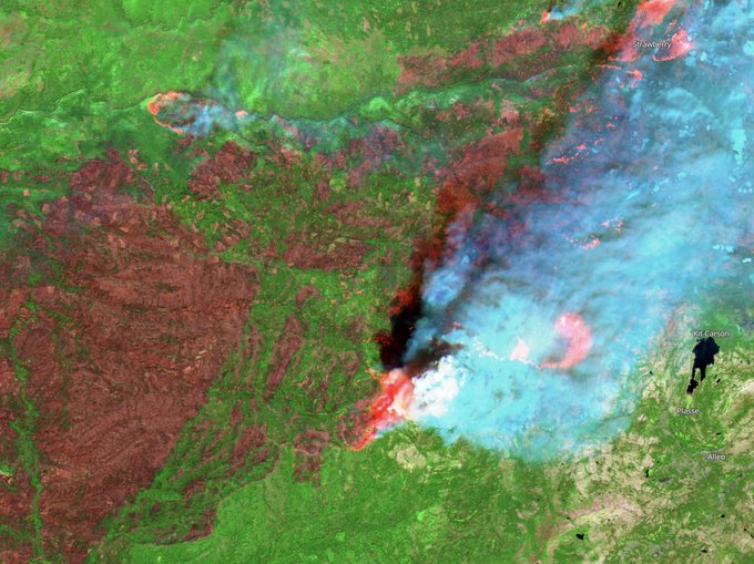
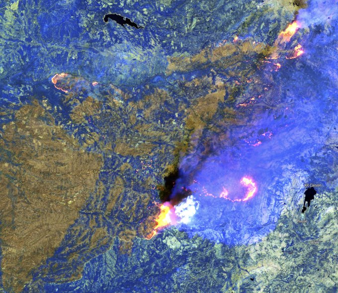
Communicator covering water and wildfire.
Working in forests since 1990.
Founder
@DeerCrResources
.
Intel = public data.
Photos by me.
Fire is the best teacher.
The Lookout uses open-source wildfire intelligence and decades of wildfire mapping experience to provide context, education, and realtime fire information you'll find nowhere else. We are 100% user-supported. You can support us with a PayPal subscription.
75% of water in Ca. State Water Project comes from Feather River (blue). No forest canopy in high elevations means no shade, snow melts quicker, and we have less water available late in the summer. It's a really big deal. Here is the area burned in past 12 months.
#DixieFire
#DixieFire
photographers, could you show more respect for the locals? Shocked people returning to ruins of their town makes for gripping material, but it's hard to describe how hard it sucks to see pictures of our communities/friends in such despair. Seems exploitative.
A Lookout supporter saw me struggling with livestreaming the other night. Today they drove 3 hours to my house, gave me a nice laptop, and spent a couple hours helping me get things dialed in for broadcasting. So very much appreciated!
If there is a lesson to share from past month of consistent losses fighting
#DixieFire
,
#CaldorFire
is beyond our control until weather cooperates. Don't assume firefighting will succeed. If you are anywhere above Hwy 49, between Hwy 50 and Hwy 4, you should be prepared to leave.
#CaldorFire
- 8/31/2021 Morning.
Many mapping websites use satellite heat detections to show dots for fire location. These are inaccurate, not intended for tactical use. Aerial mapping flights, much more accurate, DO NOT show fire in town at 5:20 am. Please don't spread bad info.
There is a staffing crisis unfolding in the wildland fire world. Incident command teams can't roster enough people to respond to large fires, and many that are getting staffed are short in key positions. This will be a major issue in 2022. Here are some firefighter perspectives:
15,000 followers! Up from 800 in the beginning of August. If our communities are going to survive, wildfire is one of those topics we all need to learn more about. I'm honored so many people want to hear what I have to say. Thanks to everyone supporting The Lookout project.
We have had a month of great conditions for prescribed fire in Northern California. Why haven't we burned tens or hundreds of thousands of acres during this time? What are we waiting for? Our communities can't wait. We need to get on it.
#McKinneyFire
ended up burning about 60,000 acres. Estimated firefighting costs to date are around $60M. We spent $1,000/acre, and all we have to show for it is a devastated forest and millions of dead fish. Investing in forest health is cheap, in comparison.
#DixieFire
8/12/2021 - 9:30pm.
Things are definitely not looking so sharp for my hometown of Westwood. This mosaic of the FLIR imagery from Dyer Mountain looks north.
If tonight is her night, She went down in about the biggest blaze of glory ever. We love you, Westwood!
The Feather River Watershed supplies the largest reservoir in the State Water Project which 27m Californians & 750k acres of farmland rely on. In 2020 & 2021 it 🔥 like never before creating significant risks for 💧 quality & timing from the loss of 🌲cover.
#CAfire
#CAwater
We're not just letting it burn. It is kicking our asses every day. We could have all the firefighters and resources from
#CaldorFIre
and it wouldn't materially change the outcome.
#DixieFire
has been beyond our control for 50 days and will continue to be until weather changes.
I've decided to become a weather livestreamer. Currently stuck in a blizzard on Donner Summit. This is a shot out my windshield. Follow me for more exciting and dangerous first-person reporting, and please send help!
#satire
#stayhome
#weknowwhatsnowlookslike
Satellite heat detections for the Texas Panhandle show 1.2M acres of fire spread over 100 miles east to west. This perimeter is from data current thru 2/26/24, about 9pm, Central Time.
#TexasFires
#DixieFire
is beyond control until we get socked in with smoke again. Then it will likely run again when the lid comes off. Some things are beyond our control. It is really important we are honest about this with the public... Read why I think this, here:
#CaldorFire
- 8/29/2021 Evening Video
Here is The Lookout's first video project. This shows current IR heat mapping of the Caldor Fire as of 5:20 pm on 8/29/2021.
via
@YouTube
#CaldorFire
8/18/2021 Update.
Infrared mapping from 5pm flight today. Fire spread 13 miles east in past 24 hrs. Fire was 13 miles east of Placerville at 5pm. Winds forecast to blow hard toward west tonight. If you are living west of fire pay attention to conditions overnight.
#DixieFire
- 8/5/2021 - Afternoon Update.
Well, things are really going to hell on the Dixie Fire.
The forecast frontal passage is starting to affect the fire, winds are shifting to out of the west... {read more}
8/4/2021 -
#DixieFire
Today was a really bad day in the Upper Feather River. About as bad as a day can get for most of us. There is a lot of bad news, and some hopeful news, too. I just posted IR maps from this evening's overflights:
At 2:45 pm, there is a spot of fire between Hwy 50 and Old Meyers Grade Rd, east of Berkeley Muni Camp. No other heat showing on Valley floor at that time. Please don't share satellite heat maps showing fire all over the Valley unless you have confirming intel.
#CaldorFire
#CaldorFire
9/1/2021 Morning Update.
Overnight IR shows no new spread into urbanized areas of SLT/Meyers. Some spread on northern flank east of Kyburz toward Wrights Lake. Will have updates later in the day.
#CaldorFire
- Wildland Urban Interface.
The fire is burning adjacent to US Route 50, the most densely-developed portion of the Sierra Nevada Mountains.
Each dot here shows a home or other structure.
Source:
@CalTopoMaps
National Geographic's article about
#DixieFire
/
#LassenPark
is disappointing. It follows a tired storyline that casts fire as a villan that just created a 'New Devastated Area'. The real story is managed fires in Lassen, which made Dixie less destructive.
@natgeo
can do better.
Several of my prescribed burning colleagues have been working hard on legislative fixes to make it easier to burn on private lands in California.
As a result, 2 new bills are on the Governor’s desk. Please consider writing letters of support.
So
#wildfire
season is finally starting to take off in Northern California. Here is a thread on why it has taken this long, and what it takes for us to have large fires in California:
#CaFires
#CaWx
#WildlandFirefighting
1/
Not a denier, but I feel blaming climate change for wildfires does a disservice to both issues. With or without climate change California would have major wildfires. Look at the fire history. The annual acreage burned before suppression began dwarfs what we are seeing now.
Please, let’s stop calling these wildfires. These are human caused firestorms fueled by our inaction on climate change and usually ignited by human error. And it’s not just a California problem. Burning coal in your state? It helped fuel this fire in my backyard. 😞
#oakfire
My congressman, Doug LaMalfa is poorly informed. Not only is putting out every fire impossible, it has also proven to be the worst possible thing for the health of our forests. To use proper forestry lingo, Doug LaMalfa and Tom McClintock are a couple of culls.
This piece of paper represents 25 years of work. Grateful for mentors and friends who did the political legwork, who fought for permits, kept the skills alive, and made it possible for me to spend so much time with
#goodfire
. Lots of work to be done, let's do it together!
#CaRX
#CaldorFire
- 9/2/2021, Morning Update
Just posted a video briefing with heat mapping from 3am, 9/2/2021. We look at where the fire is active around Meyers and Christmas Valley, Kirkwood, and Echo Lake. Also, I talk about our plans for The Lookout.
There is some spooky stuff going on on the south end of
#McKinneyFire
as outflow winds from thunderstorms push the fire downhill over the ridge toward Scott Valley.
The Lookout will be covering on the upcoming California 'atmospheric river' storms, mostly on Twitter. We aren't meteorologists, but we'll use all the tools in our mapping and intel toolboxes to bring you information, context, and situation awareness.
#CaldorFire
- 8/31/2021 4:45 pm heat mapping:
Not much fire spread into communities in SLT/Meyers at this time. Fire made a 5 mile run east to top of Trimmer Peak. Fire close to Kirkwood. Video update at:
#DixieFire
- Friday the 13th.
As of 2:30 am, Westwood, Clear Creek, Hamillton Branch, and the Peninsula have NOT been impacted by the fire, but it is doing its best to kill us all with anxiety before it gets there. Updated Maps from 2 am. Janesville ok.
#CaldorFire
9/2/2021 Evening Update
No detailed heat mapping available this evening. Sounds like firefighters made a lot of progress today. We'll have updated maps in the morning.
I'm starting a new project - a website called 'The Lookout'! Kind of tied up with the whole world around my hometown burning, but I want to write more about wildfire and interview people I've worked with over the past 25 years. Please consider supporting .
#CaldorFire
- 8/31/2021 Morning Mapping.
The fire jumped across Christmas Valley and ran hard to the norheast. It had avoided most of the urbanized area at 1:51 am, but there is a large amount of perimeter 3/4 mile SE side of Pioneer Trail that may be impacted today.
It's that time of the year, again,
When I try to hold my tongue
As US Forest Service social media
Brags about putting out every
Little lightning fire.
As if we don't know better by now.
Forests need fire.
Lightning is God's work.
Would you rather fight it in August?
Not me.
Spent two days surveying wildfire hazards a stone's throw from Stanford for
@DeerCrResources
. Speechless at just how dangerous conditions are there, in some of the wealthiest zip codes in the world. Very real potential for wildfires that'll make
#CampFire
look inexpensive. 1/
Just installed the wildfire-tracking
@watchdutyapp
on my phone. I had been using it in a browser... They're doing a great service. The app is really straightforward, and I really like being able to see recent fire footprints on the map. Strong work!
#DixieFire
- 8/6/2021
Heavy smoke and calmer winds are helping keep fire spread on the Dixie Fire less severe today. Many areas the fire creeps through under these conditions will actually benefit from the fire. Not a lot of new intel to share.
The Lookout website is one month old today. We've gotten about a million views and posted over 1,000 maps. If you have started following me in past week or two, you might have missed some earlier stories. Here's one on people living in
#DixieFire
area.
It's been a tough week at Firestorm since we lost Darin Banks to a snag while his crew was prepping firelines for a burn. We are driving him home today, and the support we are getting from fire departments along the route is incredible. Thank you all!
#WashburnFire
just punched thru the inversion layer, is going to gobble some of the South Merced Canyon for rest of the afternoon. Good news is it looks like the head is going around the Mariposa Grove, which has seen minimal spread so far. 7/9/2022 - 15:25pm/
While we were watching the
#MillFire
unfold, a new start about 15 miles west took off and grew 1,500 acres in a matter of hours. The
#MountainFire
will be with us longer, and become much larger than the
#MillFire
. We'll cover it tomorrow on the Lookout YouTube Channel at 0700.
Let's talk lightning!
At least once a decade in California, a few hours of abundant and widespread 'dry lightning' (no rain) turn an average wildfire season into an exceptional one. Thousands of wildfires start. Some grow large, and burn until fall rains come. /1
The
#ColoradoFire
(red) is burning in a piece of the Coast that the 2016 Soberanes Fire (blue) didn't reach. A contract bulldozer operator died in a rollover trying to keep the fire out of this particular area.
As
#WashburnFire
winds down, I have to admit several of my predictions were wrong. I didn't think they'd hold the fire at Iron Creek, or that retardant would hold the southeast flank. I thought it might burn all summer. Thanks to the people who made sure it wouldn't.
The large
#wildfires
in
#Chile
are spreading quickly across large areas of non-native plantations of radiata pine and eucalyptus, many of them planted by foreigners during a dictatorship. These maps show recent MODIS heat detections on top of mapping of plantations (purple). 1/x
#DixieFire
- 8/5/2021 - 8pm Update.
Very dynamic day on the fire. Lots of things made big moves to the east. Updated IR maps and discussion on the -lookout.org.
Thanks for all of your continued support and good luck to everyone evac'd!
It is hard enough to work on a large team when you are winning, and nearly impossible when you keep losing. Realize firefighters are beyond their limits with the fire behavior we are seeing. The best we can hope for in the next few days is to not kill our firefighters.
#CaldorFire
9/1/2021 - Midday
Waiting on updated mapping to have something to share. Will post as soon as data is available and I have time to interpret!
Big new article and op-ed about the
#DixieFire
and firing operations in an era of megafires.
Escaped firing operations dominate today's post on the Dixie Fire, and it seems like a good time to talk about when, why, and where we use these tactics.
The Governor just signed prescribed fire liability legislation which will make it easier to put
#goodfire
on the ground in California. Much appreciation to everyone who worked to make this happen. Just finished washing red dust off my boots after scouting burns in Forest Ranch.
Newsom just signed SB332, making CA a gross negligence state for suppression costs associated with
#rxfire
and giving cultural burners the same standing as burn bosses. This is a huge moment for CA and I’m so proud to have worked on it with
@MichaelWWara
&
@SenBillDodd
! 🎉❤️🔥
The
#DixieFire
has been harrowing for everyone affected, and the losses are staggering. But in many places, the fire played its natural role - cleaning up and thinning our overgrown forests. This video surveys the fire effects at one of my favorite places.
Audio of radio traffic between pilots after a near miss between a large tree branch falling from the column and a large airtanker this afternoon on
#WashburnFire
. No such thing as low-risk summertime mountain aviation.
#WashburnFire
interesting little chat. Near miss with a tree branch and Air Attack and Tanker 103. As civilians, we just see planes dropping loads. But listen to this choreography that goes on behind the scenes of fire.
#CaldorFire
- 8/31/2021 Morning Maps v2.0
Major activity on SE side of the fire near Kirkwood, where a large firing operation took place along Highway 88 overnight. Detailed maps on The Lookout. I'll update the post with forecasts and narrative by 9am.
10/12/2021 - 5pm
#AlisalFire
update.
At about 5pm, fire was about 13,000 acres and had spread about 2.5 miles east and 1.25 miles west since 4am. Red outline shows 5pm perimeter, white line is 4am perimeter. Blue is 2016 Sherpa Fire, purple is 2017 Whittier Fire.
#TheLookout
Evacuation is often impossible during fast-moving wildfires because most of our towns weren't designed with fire in mind. Parks and parking lots can be good places to wait out a fire. If you are evacuating and traffic is backing up, never pass up a good safety zone!
The
#AirportFire
is burning over near Highway 395 in Owens Valley, near Big Pine. Winter fires are common on the Eastside of the Sierra, and this fire should not be framed as evidence the whole State is about to go into fire season in February. Map from 'muni_captain'.
100 yrs waging war on fire & criminalizing its use gave us broken forests and towns on the brink. We won many battles, but w/ climate change as ally, fire won the war. As long as we refuse to surrender, fire will keep up a siege until every last mtn town and green tree lay in ash
The view at Kings Creek Upper Meadow remains as scenic as ever. The
#DixieFire
burned at low-intensity around the meadow toward the base of Reading Peak. The large rocky outcroppings provided a natural barrier to help slow fire activity.
Areas like this desperately need prescribed fire and managed wildfire. We've put out dozens of fires over the years that would have backed thru here with low intensity; now we've roasted some of the most majestic old-growth anywhere in Northeastern California. I'm fucking gutted.
Susanville Dispatch just asked everyone to take a moment of silence. On this day in 2013, Lassen County local Luke Sheehy was killed smokejumping a fire in the Warner Mountains. Luke's former crew, the Diamond Mountain 'Shots, is currently busting their asses on the
#GrahamFire
.
Had
@Pyrogeographer
as my firing boss today, and then he and I sat down with
@wkamaubell
for an extended and free-ranging talk about wildfire as a permanent resident of California. Look for the United Shades of America episode on CNN and HBO+ in April.
#CaldorFire
8/29/2021 - 7am Update.
Fire is established at Lovers Leap, 2.5 miles upcanyon from where it was 28 hours ago, and past major dozer lines in Strawberry Creek. Fire is now 5.5 miles from Echo Summit. NW side of fire moved 1/2 mile west. More at:
Citizen-led prescribed fire is the way of the future. We can't wait for State and Federal agencies to lead the way. We need to take responsibility for the tending of our own places and communities. We are preparing for a similar event this winter here in Butte County, stay tuned.
8/2/2021 - 20:00 hrs
Truly incredible fire behavior this afternoon as the
#DixieFire
blew across Humboldt Road and ran up into the Butt Mountain Roadless Area, south of Black Forest Lodge on Highway 36. This area of old-growth fir forest has never been roaded, logged or burned.
This is Sly Park Road in Pollock Pines. This is what evacuations currently look like for miles and miles heading out of the area as we head in to bring you current info. Obviously one lane roads make evacuations lengthy and long.
#CaldorFire
- 8/31/2021, 8pm Update.
We got some fresh heat mapping data for the fire from 8 pm, and published another video briefing. This one also covers Kirkwood, Somerset, Pleasant Valley, and the Highway 50 Corridor.
Burning about 185 acres around Chico Airport today with
@ChicoFD
. Objectives are to create a buffer for city of Chico from fall wildfires, train city firefighters, and reduce medusahead grass. Light breeze, hot and dry, perfect conditions to meet the objectives.
#goodfire
Got credit on a byline for a National Geographic map about the
#WashburnFire
. I didn't make the map, but the cartographer used some of my reporting to piece together the story. Feels like being nominated for the Cartography Hall of Fame, thanks,
@NatGeo
!
There is an IR flight ordered for
#McKinneyFire
tonight so unless it is too cloudy, we should have some fresh intel for everyone in the morning. Thanks for your comments and information sharing today, everyone!
Just posted a virtual tour of the
#McKinneyFire
to The Lookout YouTube channel. It has mapping of the fire captured about 12:30 am, 7/31/22, and discusses fire behavior and land management history for the burned area.
I just got an early Christmas present from the California State Fire Marshal!
It's been a long time coming, and I'd like to shout out to all of the people who have mentored me and given me time with
#GoodFire
.
I'm consulting under the umbrella of
@DeerCrResources
. Call us!
Simultaneous blowups on the
#MosquitoFire
in past hour. On the NW flank, the fire has crossed M. Fk American River and is headed to Foresthill. On the east flank a very broad area is under a massive plume. Here are views to the east and of the NW blowup. 15:30, 9/13/22
Just finished a 60 minute livestream about the current major wildfires around California. We talked about the potential for the
#MosquitoFire
to spread toward Georgetown or Lake Tahoe, and what past fires in this area might tell us about what's to come.
Thinking about black oak forests today, and how they may be key to saving what's left of our foothill communities in Butte County. Oaks are much less flammable than conifers. Also, acorns form the base of our forest food web, feeding deer, turkeys, squirrels, birds, and people.
#CaldorFire
- 8/22/2021 Evening Update.
No new growth to the east, some spread to N & S on east edge of the fire. Fire grew slowly to SE, mostly less than 1/4 mi. Longest run was a mile. Westward spread in M. Fk. Consumnes near Omo Ranch and Camp Creek.
Welcome to Plumas County. So this slide isn't under the
#DixieFire
burn, but area above burned in 2020
#BearFire
. Dixie did burn right across the Canyon, though.
#2021Storm
Water managers have it tough in California. They have to keep reservoir levels low enough to control flooding during major storms, while trying to store as much water as possible for long summers. They rely on data from thousands of sensors.
#hydrology
1/
There's no doubt a warmer climate affects fire behavior. But bundling the issues muddles the way forward. The solution to wildfires isn't carbon offsets or cap and trade. And framing wildfires as purely detrimental undermines fire ecology and traditional ecological knowledge.
#DixieFire
- 9/12/2021.
We got a chance to survey the burned area in West Zone of the Dixie Fire on 9/10/2021, right after about 1/2" of rain. This video explores the wide variety of fire effects across the burned area, and talks about some of the causes.
#CaldorFire
9/1/2021 Afternoon Update:
No new heat in neighborhoods in Meyers or Christmas Valley. Only minor spread anywhere on east side of fire showing at 2:40 pm. Some spread to north, east of Kyburz. South side of fire fairly quiet. Detailed maps at .
Got to help put 10 acres of
#goodfire
on the ground today in the Butte County Foothills with a crew of locals. This is our 4th burn on this property, where we are building a toehold to do larger, more complex burns in an area with critical WUI wildfire hazards.
#buttetrex
.