Copernicus EMS Profile Banner
Copernicus EMS Profile
Copernicus EMS

@CopernicusEMS

68,066
Followers
1,584
Following
6,099
Media
38,916
Statuses

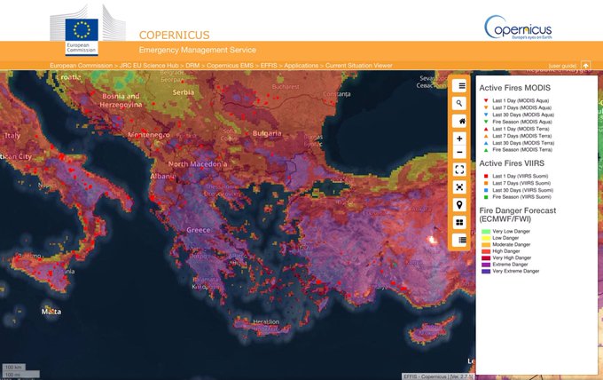
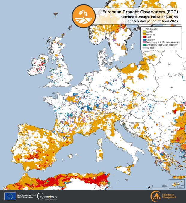
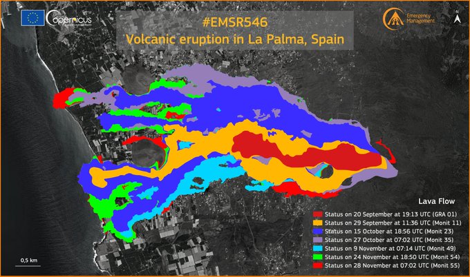
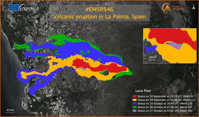
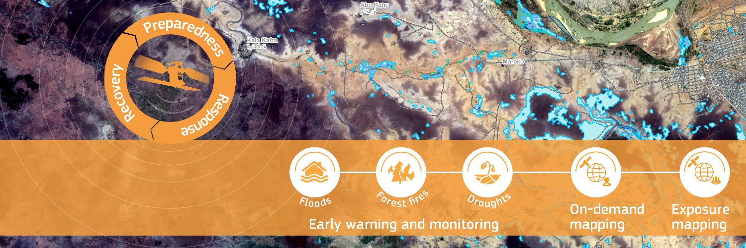
Copernicus Emergency Management Service provides mapping products based on satellite imagery as well as #ForestFires #Flood and #Drought early warning products.

European Commission
Joined November 2013
Don't wanna be here? Send us removal request.
Pinned Tweet
@CopernicusEMS
Copernicus EMS
4 days
From November 2023 to March 2024, #drought 🚱conditions affected the Zambezi River Basin, causing river flows to decrease to record lows 🔽Meteorological drought tracking for the 3rd 10-day period of March Read our latest #GDO report at👇
Tweet media one
1
18
25
@CopernicusEMS
Copernicus EMS
5 years
These are the active fires in the #Amazon basin, from the Global Wildfire Information System we are developing with @NASAEarth and @GEOSEC2025 In red the fires detected in the past 24h, in orange those from the past week #NoComment
Tweet media one
Tweet media two
42
1K
2K
@CopernicusEMS
Copernicus EMS
3 years
🔴Breaking #EMSR546 #Erupci ónLaPalma Night shift for our #RapidMappingTeam They released at 04:14 UTC a grading map for the #LaPalma eruption using #Sentinel1 🇪🇺🛰️ & COSMO-SkyMed radar images Their maping product shows 166 buildings destroyed 🏘️ Lava flow covers 103 ha 🌋
Tweet media one
32
814
1K
@CopernicusEMS
Copernicus EMS
5 years
We have finished processing several versions of today’s #Sentinel2 🇪🇺🛰 acquisition over Gran Canaria’s #IFValleseco 🇪🇸 fire They show the incredible complexity of the situation facing the on-site teams: mote than 10 fronts, intense heat, etc All our thoughts are with them...
Tweet media one
Tweet media two
Tweet media three
27
1K
1K
@CopernicusEMS
Copernicus EMS
4 years
Storm #Gloria has caused a storm sturge that has ravaged the Ebro delta up to 3 km inland, resulting in severe damage to the rice paddies Before/after comparison using a #Sentinel1 🇪🇺🛰 radar image acquired yesterday 22 January @astro_duque @mapagob @el_pais @europapress
16
923
653
@CopernicusEMS
Copernicus EMS
3 years
#EMSR546 #Erupci ónLaPalma Our #RapidMappingTeam has released its 1️⃣7️⃣th updated product for #LaPalma 🇪🇸 #CumbreVieja eruption using an optical image acquired on 8 October at 12:06 UTC ▶️Extent of the🌋lava flow: 497 ha (+16.5 ha in 24h) ▶️1,186 destroyed buildings🏠detected (+37)
Tweet media one
9
237
621
@CopernicusEMS
Copernicus EMS
3 years
#EMSR546 #Erupci ónLaPalma Our #RapidMappingTeam has released its 9th monitoring product for #LaPalma 🇪🇸 using a new radar image It shows: 🏠589 buildings destroyed (+76 compared to Monit08) 🌋the lava flow covers 258 ha (+20.5 ha in 19h) 🚧 21 km of roads destroyed
Tweet media one
6
359
602
@CopernicusEMS
Copernicus EMS
3 years
EMSR546 #Erupci ónLaPalma Our #RapidMappingTeam has released its 2️⃣0️⃣th updated product for #LaPalma 🇪🇸 #CumbreVieja eruption using a radar image acquired on 13 October at 06:50 UTC ▶️Extent of the🌋lava flow: 680.4 ha (+24.4 ha in 24h) ▶️1,548 destroyed buildings🏠detected (+90)
Tweet media one
3
274
566
@CopernicusEMS
Copernicus EMS
3 years
#EMSR546 #Erupci ónLaPalma Our #RapidMappingTeam has released a 3rd monitoring product for #LaPalma 🇪🇸 using a new radar image It shows: 🏘️ 390 buildings destroyed (+40 compared to 22 September) 🌋 The lava flow covers 180,1 ha (+14 ha in 11h) 🚧 14 km of roads destroyed
Tweet media one
3
290
550
@CopernicusEMS
Copernicus EMS
3 years
#EMSR546 #Erupci ónLaPalma Our #RapidMappingTeam has released its 1️⃣9⃣th updated product for #LaPalma 🇪🇸 #CumbreVieja eruption using a radar image acquired on 12 October at 06:50 UTC ▶️Extent of the🌋lava flow: 656 ha (+86.4 ha in 43h) ▶️1,458 destroyed buildings🏠detected (+135)
Tweet media one
1
258
554
@CopernicusEMS
Copernicus EMS
3 years
EMSR546 #Erupci ónLaPalma Our #RapidMappingTeam has released its 2️⃣2⃣nd updated product for #LaPalma 🇪🇸 #CumbreVieja eruption using an optical image acquired on 15 October at 12:10 UTC ▶️Extent of the🌋lava flow: 736.9 ha (+4.4 ha in 9h) ▶️1,826 destroyed buildings🏠detected (+9)
Tweet media one
2
265
543
@CopernicusEMS
Copernicus EMS
5 years
Continuing our (unofficial) monitoring of #Siberia #wildfires This one is at 70.9° North and 60 km from the shores of the Sytygan Tala Bay, in the Laptev Sea A rough estimate puts the burn scar at around 60 km2 #savesiberiaforests #потушитепожарывсибириin
Tweet media one
15
372
489
@CopernicusEMS
Copernicus EMS
10 months
According to our European Drought Observatory #EDO CDI, in the 1st 10-day period of June: ▶️The Iberian Peninsula continued to be the area most affected by #drought 🚱 🟠3⃣7⃣.3⃣% of the EU-27 territory in Warning conditions (+10.4%❗️) 🔴1⃣0⃣.2⃣% in Alert conditions (+0.2%)
Tweet media one
15
375
536
@CopernicusEMS
Copernicus EMS
3 years
EMSR546 #Erupci ónLaPalma Our #RapidMappingTeam has released its 2️⃣2⃣nd updated product for #LaPalma 🇪🇸 #CumbreVieja eruption using radar imagery acquired on 15 October at 18:56 UTC ▶️Extent of the🌋lava flow: 753.8 ha (+16.9 ha in 7h) ▶️1,835 destroyed buildings🏠detected (+9)
Tweet media one
10
209
516
@CopernicusEMS
Copernicus EMS
3 years
#ERCC #DailyMap : 2021-09-21 ⦙ Spain, Canary Islands (La Palma) | Cumbre Vieja volcanic e… ▸
Tweet media one
5
266
493
@CopernicusEMS
Copernicus EMS
3 years
#EMSR546 #Erupci ónLaPalma🌋 Our #RapidMappingTeam released its 1️⃣3️⃣th updated product for #LaPalma 🇪🇸 Volcano using a Very High Resolution Satellite image acquired on 1 October ▶️ Extent of the 🌋lava flow: 367.3 ha ▶️ 880 destroyed 🏠 have been detected
Tweet media one
4
235
496
@CopernicusEMS
Copernicus EMS
3 years
#EMSR546 #Erupci ónLaPalma Our #RapidMappingTeam has released its 1️⃣6⃣th updated product for #LaPalma 🇪🇸 #CumbreVieja eruption using an optical image acquired on 7 October at 12:13 UTC ▶️Extent of the🌋lava flow: 480.5 ha (+45.8 ha in 4 days) ▶️1,149 destroyed buildings🏠detected
Tweet media one
3
213
490
@CopernicusEMS
Copernicus EMS
3 years
#EMSR546 #Erupci ónLaPalma Our #RapidMappingTeam has released its 2️⃣4⃣th updated product for #LaPalma 🇪🇸 #CumbreVieja eruption using optical imagery acquired on 17 Oct. at 11:47 UTC ▶️Extent of the🌋lava flow: 789.6 ha (+35.8 ha in 41h) ▶️1,835 destroyed buildings🏠detected (+121)
Tweet media one
5
210
473
@CopernicusEMS
Copernicus EMS
3 years
#EMSR546 #Erupci ónLaPalma Our #RapidMappingTeam has released its 6th monitoring product for #LaPalma 🇪🇸 using the 1st cloudless optical image acquired since the eruption started It enables to refine damage grading & to identify areas affected by the ashfall which covers 1,314 ha
Tweet media one
3
216
465
@CopernicusEMS
Copernicus EMS
5 years
Animation of the #IFvalleseco evolution over time, as seen by #Sentinel2 🇪🇺🛰 Awesome work by @annamaria_84
6
431
461
@CopernicusEMS
Copernicus EMS
3 years
#EMSR546 #Erupci ónLaPalma Our #RapidMappingTeam has released a second monitoring product for #LaPalma 🇪🇸 using a new COSMO-SkyMed Second Generation radar image It shows: 🏘️350 buildings destroyed (+30 compared to 21 September) 🌋The lava flow covers 166,2 ha (+14 ha in 36h)
Tweet media one
6
213
456
@CopernicusEMS
Copernicus EMS
5 years
It seems the number #Siberia #wildfires is slowly (and finally) receding after two intense months, but large ones remain active, such as this one in the Chukotka Autonomous Okrug
Tweet media one
Tweet media two
2
316
426
@CopernicusEMS
Copernicus EMS
5 years
Scorching heat over Italy today... Must have been a tough day for first responders and medical crews Land Surface Temperature (not air temperature) as measured today by #Sentinel3 🇪🇺🛰
Tweet media one
19
266
432
@CopernicusEMS
Copernicus EMS
5 years
Floods in southeast Spain 🇪🇸 This #Sentinel2 🇪🇺🛰 image acquired yesterday 13 September shows flooded areas north and northwest of Cartagena and the runoff into the Mar Menor (in blue) FYI @astro_duque Thanks to @adelgado for the cue
Tweet media one
6
331
406
@CopernicusEMS
Copernicus EMS
5 years
This is the most significant and largest wildfire currently burning in South America It is in the border area between #Brazil , #Bolivia and #Paraguay and its north-south length is a mind boggling 105 km #Sentinel2 🇪🇺🛰 image acquired today 25 August More images below ⬇️
Tweet media one
5
320
402
@CopernicusEMS
Copernicus EMS
3 years
#EMSR546 #Erupci ónLaPalma Our #RapidMappingTeam released its 12th updated product for #LaPalma 🇪🇸 Volcano using a Very High Resolution Satellite image acquired on 30 Sept. ▶️ Extent of the 🌋lava flow: 358.1 ha ▶️870 destroyed 🏠 have been detected
Tweet media one
2
166
398
@CopernicusEMS
Copernicus EMS
1 year
#EMSR648 #Earthquake in #T ürkiye🇹🇷 Our #RapidMappingTeam has delivered its Grading Monitoring Product for the #Kahramanmara ş AoI using VHR 🛰️ imagery 9⃣2⃣7⃣ affected buildings🏚️ have been detected: 🔴286 destroyed 🟠185 damaged 🟡456 possibly damaged 🔗
3
164
390
@CopernicusEMS
Copernicus EMS
3 years
📢Update2⃣6⃣ #EMSR546 #Erupci ónLaPalma For the first time in our #RapidMapping history, we have used radar imagery acquired by the PAZ🇪🇸 satellite❗️ As of 19 October at 18:56 UTC ▶️Extent of the lava 🌋 flow: 866.1 ha (+54.3ha in 48h) ▶️2185 destroyed buildings🏠 (+229 in 48h)
Tweet media one
5
213
395
@CopernicusEMS
Copernicus EMS
3 years
#EMSR546 #Erupci ónLaPalma Our #RapidMappingTeam has released its 1️⃣8⃣th updated product for #LaPalma 🇪🇸 #CumbreVieja eruption using an optical image acquired on 10 October at 11:50 UTC ▶️Extent of the🌋lava flow: 570 ha (+73 ha in 48h) ▶️1,323 destroyed buildings🏠detected (+337)
Tweet media one
1
176
393
@CopernicusEMS
Copernicus EMS
3 years
#EMSR546 #Erupci ónLaPalma Another late night delivery for our #RapidMappingTeam Using COSMO-SkyMed radar imagery they have produced an updated grading map that puts the extent of the lava at 154 ha and the number of buildings destroyed buildings at 320
Tweet media one
4
189
389
@CopernicusEMS
Copernicus EMS
3 years
#EMSR546 #Erupci ónLaPalma🌋 Our #RapidMappingTeam has released its 1️⃣5⃣th updated product for #LaPalma 🇪🇸 #CumbreVieja eruption using a satellite radar image acquired on 3 October at 18:56 UTC ▶️ Extent of the 🌋lava flow: 434.7 ha ▶️ 1046 destroyed buildings 🏠detected
Tweet media one
3
192
388
@CopernicusEMS
Copernicus EMS
3 years
#EMSR546 #Erupci ónLaPalma Our #RapidMappingTeam released its 11th updated product for #LaPalma 🇪🇸🌋 using a Very High Resolution 🛰️image 855 destroyed 🏘️ have been detected, 201 more in 28 hours ‼️ A new VHR image will be acquired today at 12:14 UTC 🔗
Tweet media one
5
214
380
@CopernicusEMS
Copernicus EMS
3 years
#ERCC #DailyMap : 2021-10-14 ⦙ Spain, Canary Islands (La Palma) | Cumbre Vieja volcanic e… ▸
Tweet media one
5
184
366
@CopernicusEMS
Copernicus EMS
3 years
#EMSR546 #Erupci ónLaPalmaVolcano Our #RapidMappingTeam released its 1️⃣4⃣th updated product for #LaPalma 🇪🇸 Volcano using a Very High Resolution Satellite image acquired on 2 October ▶️Extent of the🌋lava flow: 397.5 ha ▶️946 destroyed🏠have been detected
Tweet media one
1
197
349
@CopernicusEMS
Copernicus EMS
8 months
Update #Floods in #Greece 🇬🇷 #EMSR692 Our #RapidMappingTeam has delivered its Monitoring Product for the areas affected by the catastrophic #floods in the #Thessaly region 🌊A total flooded area of 7⃣2⃣,9⃣5⃣0⃣ ha has been detected Read more at👇
Tweet media one
7
254
351
@CopernicusEMS
Copernicus EMS
2 years
#EFFIS Fire Danger Forecast for 18 July 🔥Very Extreme Danger forecasted in: ➡️Large parts of #Spain 🇪🇸, except in Catalonia and Galicia ➡️Occitanie, Pays de la Loire and Brittany, #France 🇫🇷 ➡️North Eastern #Portugal 🇵🇹 ➡Greek 🇬🇷Islands & east of Athens ➡Western #Turkey 🇹🇷
Tweet media one
9
282
349
@CopernicusEMS
Copernicus EMS
2 years
Unusual Fire Danger Forecast from our #EFFIS European Forest Fire Information System: "Very Extreme" Danger over a large area in #England , spanning from Lincolnshire to the Thames Estuary, while "Extreme Danger" should prevail in most of the east of the country #CEMS #wildfires
Tweet media one
6
182
342
@CopernicusEMS
Copernicus EMS
9 months
#EMSR686 #Alexandroupolis #Greece 🇬🇷 Our #RapidMappingTeam has delivered its 2⃣nd Monitoring Product for the large #wildfire burning in East Macedonia and Thrace Region With a total burnt area of 7⃣2⃣,3⃣4⃣4⃣ ha🔥, this wildfire is the largest recorded on 🇪🇺European soil in years
Tweet media one
22
349
342
@CopernicusEMS
Copernicus EMS
3 years
#EMSR546 #Erupci ónLaPalma A volcanic eruption is ongoing on the island of #LaPalma , Canary Islands 🇪🇸 Our #RapidMapping Team has been activated by @proteccioncivil & will use #Sentinel2 🇪🇺🛰️ today ⬇️Hotspots from the 🌋 lava & resulting #fires are visible in our #EFFIS viewer
Tweet media one
5
171
344
@CopernicusEMS
Copernicus EMS
4 years
Storm #Gloria has caused a storm sturge that has ravaged the Ebro delta up to 3 km inland, resulting in severe damage to the rice paddies and to the ecosystem #Sentinel1 🇪🇺🛰 radar image acquired yesterday 22 January See before after comparison below
Tweet media one
9
407
334
@CopernicusEMS
Copernicus EMS
4 years
¡Feliz Día de los Reyes a nuestros amigos, colegas, usuarios y seguidores españoles! A veces la naturaleza también nos trae regalos Estas imágenes de #Sentinel2 🇪🇺🛰️muestran que la cobertura vegetal se está regenerando en partes de la zona quemada el verano pasado en Gran Canarias
7
139
321
@CopernicusEMS
Copernicus EMS
3 years
📢Update #EMSR546 #Erupci ónLaPalma Our #RapidMapping has delivered its 2⃣7⃣th updated map based on optical imagery As of 21 October at 12:06 UTC ▶️Extent of the lava flow: 886.6 ha ▶️2,122 destroyed buildings🏠 ▶️6,800 ha covered by ashfall in the Area of Interest
Tweet media one
2
157
326
@CopernicusEMS
Copernicus EMS
2 years
#EFFIS Fire Danger Forecast for 25 July 🔥Very Extreme Danger in several areas of #Portugal 🇵🇹, #Spain 🇪🇸, #Italy 🇮🇹, #Greece 🇬🇷, #Morocco 🇲🇦, #Tunisia 🇹🇳 and #Algeria 🇩🇿 🔥Extreme Danger forecasted in areas of: 🇵🇹🇪🇸🇫🇷🇮🇹🇬🇷🇦🇹🇸🇰🇷🇴🇷🇸🇭🇷🇬🇧🇧🇦🇲🇪🇦🇱🇹🇷🇩🇿🇹🇳🇲🇦
Tweet media one
10
185
297
@CopernicusEMS
Copernicus EMS
6 months
#EMSR703 #Mexico 🇲🇽 Our #RapidMappingTeam has delivered 2 grading products to assess the damage caused by #Hurricane #Otis 🌀 As of 28 October, 4685 ha of built-up area🏘️ have been affected in the Acapulco coast Area of Interest More at👇
Tweet media one
3
189
309
@CopernicusEMS
Copernicus EMS
5 years
Today the #Sentinel3 🇪🇺🛰️ orbit took the @CopernicusEU spacecraft over Gran Canaria at 11:19:45 UTC These are the views captured by the SLSTR instrument (showing hot spots) and by the #OLCI (showing the smoke plume) #Sentinel2 passed ~ 4 hours ago and we are expecting images soon
Tweet media one
Tweet media two
11
302
303
@CopernicusEMS
Copernicus EMS
2 years
According to the latest data from our European Drought Observatory #EDO for its Combined Drought Indicator, which is visualised in this map 2⃣6⃣% of the 🇪🇺 territory is in 'Alert' conditions🔴 This is 1⃣ point above the figure for the previous ten-day period which stood at 25%
Tweet media one
2
162
285
@CopernicusEMS
Copernicus EMS
3 years
#EMSR546 #ErupcionLaPalma Our #RapidMappingTeam has released its 8th #LaPalma 🇪🇸 eruption monitoring product It is the 1st Grading Product based on cloud free VHR optical imagery It shows 🌋237.5 ha of lava extent 513🏠 & 18.9 km of roads🚧 destroyed 💨1,507 ha of ash fall
Tweet media one
3
170
290
@CopernicusEMS
Copernicus EMS
11 months
According to our European Forest Fire Information System #EFFIS 🔥 The Fire Danger Forecast Anomaly for 7 June shows 🟤"Extreme Anomaly" levels ➡In areas of 🇨🇮🇬🇧🇮🇸🇫🇷🇧🇪🇳🇱🇱🇺🇩🇪🇸🇪🇵🇱🇱🇻🇱🇹🇺🇦🇲🇩🇷🇴 More👇
Tweet media one
18
191
284
@CopernicusEMS
Copernicus EMS
2 years
#EMSR546 #Erupci ónLaPalma #CumbreVieja It has been 2⃣ months since the volcanic eruption on #LaPalma started‼️ With 5⃣3⃣ products and 1⃣0⃣4⃣ maps, our #RapidMappingTeam has proven to be a useful asset for monitoring the consequences of disasters in support of local authorities
Tweet media one
Tweet media two
Tweet media three
3
104
286
@CopernicusEMS
Copernicus EMS
3 years
#EMSR546 #Erupci ónLaPalma #CumbreVieja #LaPalma Our #RapidMappingTeam has delivered its 2⃣9️⃣th updated map It is based on COSMO-Skymed NG radar imagery As of 23 October at 07:14 UTC: ▶️ Extent of the lava flow: 891,9 ha (+14 ha in ~12h) ▶️ 2,143 destroyed buildings🏠 (+14)
Tweet media one
3
108
280
@CopernicusEMS
Copernicus EMS
3 years
#EMSR546 #Erupci ónLaPalma Today’s optical acquisition was cloudy, so our #RapidMappingTeam is using the COSMO-SkyMed NG radar image below, acquired this morning at 07:14 UTC, to produce its 2️⃣9️⃣th updated map Many thanks to @ASI_spazio and @e_geos for providing the imagery!
Tweet media one
5
94
281
@CopernicusEMS
Copernicus EMS
3 years
#EMSR546 #Erupci ónLaPalma Our #RapidMappingTeam has released its 3️⃣0️⃣th updated map It is based on COSMO-Skymed NG radar imagery As of 24 October at 07:14 UTC: ▶️ Extent of the lava flow: 901.2 ha (+9.3 ha in ~24h, from a new soutern🌋 flow) ▶️ 2,146 destroyed buildings🏠 (+3)
Tweet media one
2
110
274
@CopernicusEMS
Copernicus EMS
11 months
Our European #Drought Observatory #EDO provides information on current droughts in Europe🚱 ⬇️In the period from 11 to 20 May 2023 all of the Iberian peninsula was in 🔴Alert or 🟠Warning conditions More at👇
Tweet media one
1
152
261
@CopernicusEMS
Copernicus EMS
2 years
#EMSR546 #Erupci ónLaPalma #CumbreVieja Our #RapidMappingTeam has released its 5️⃣0️⃣th updated map It is based on @ASI_spazio COSMO-Skymed 🛰 radar imagery As of 12 Nov. at 07:02 UTC: ▶️Extent of the lava flow: 1,018.9 ha (+19.3 ha in 3 days) ▶️2,616 destroyed 🏡buildings (+11)
Tweet media one
4
110
255
@CopernicusEMS
Copernicus EMS
3 years
#EMSR546 #Erupci ónLaPalma #CumbreVieja Our #RapidMappingTeam has released its 3⃣9️⃣th updated map It is based on @AirbusSpace #Pl éiades 🛰 optical imagery As of 31 October at 11:39 UTC: ▶️ Extent of the lava flow: 975.2 ha (+5.2 ha in ~24h) ▶️ 2,574 destroyed buildings 🏠 (+12)
Tweet media one
1
120
250
@CopernicusEMS
Copernicus EMS
2 years
#DYK that the shape of #LaPalma island is changing?💡 As of 1 December, our #RapidMappingTeam has delivered a record of 5⃣7⃣ monitoring products over #Erupci ónLaPalma The previous record was held by the activation for the 🌋eruption in Fogo Island🇨🇻 with 1⃣4⃣ products
Tweet media one
Tweet media two
Tweet media three
Tweet media four
3
95
247
@CopernicusEMS
Copernicus EMS
3 years
#EMSR546 #Erupci ónLaPalma Our #RapidMappingTeam has released its 3⃣8⃣th updated map It is based on @ASI_spazio COSMO-Skymed 🛰 radar imagery As of 30 October at 07:08 UTC: ▶️ Extent of the lava flow: 970.0 ha (+23.5 ha in ~24h) ▶️ 2,562 destroyed buildings 🏠 (+30)
Tweet media one
0
113
244
@CopernicusEMS
Copernicus EMS
2 years
#EMSR546 #Erupci ónLaPalma #CumbreVieja Our #RapidMappingTeam has released its 5⃣3⃣rd updated map It is based on @ASI_spazio COSMO-Skymed 🛰 radar imagery As of 20 Nov. at 19:32 UTC: ▶️Extent of the lava flow: 1,065.9 ha (+23.8 ha in 5 days) ▶️2,651 destroyed🏠buildings (+28)
Tweet media one
3
99
236
@CopernicusEMS
Copernicus EMS
3 years
#EMSR546 #Erupci ónLaPalma Our #RapidMappingTeam has released its 4th monitoring product for #LaPalma 🇪🇸 using a new radar image It shows: 🏠420 buildings destroyed (+30 compared to Monit03) 🌋the lava flow covers 190,7 ha (+10.6 ha in 18h) 🚧 15.2 km of roads destroyed
Tweet media one
5
119
236
@CopernicusEMS
Copernicus EMS
2 years
#EMSR546 #Erupci ónLaPalma #CumbreVieja Our #RapidMappingTeam has released its 5⃣1⃣st updated map It is based on @ASI_spazio COSMO-Skymed 🛰 radar imagery As of 13 Nov. at 18:44 UTC: ▶️Extent of the lava flow: 1,024.4 ha (+5.5 ha in ~36h) ▶️2,618 destroyed 🏠 buildings (+2)
Tweet media one
2
106
239
@CopernicusEMS
Copernicus EMS
3 years
#EMSR546 #Erupci ónLaPalma To produce our 11th updated map for the #LaPalma #CumbreVieja eruption, we have used a @AirbusSpace Pléiades VHR image, the first acquired since the lava flow reached the sea It clearly shows the change in the coastline, and the active lava rivers
Tweet media one
2
100
237
@CopernicusEMS
Copernicus EMS
2 years
#EMSR546 #Erupci ónLaPalma #CumbreVieja Our #RapidMappingTeam has released its 5⃣7⃣th updated map It is based on 2⃣ @ASI_spazio COSMO-Skymed 🛰 radar imagery As of 1 Dec at 07:08 UTC: ➡️Extent of the lava flow🌋: 1,163.7 ha (+69 ha in 1 week) ➡️2,790 destroyed buildings🏘️(+95)
Tweet media one
4
79
230
@CopernicusEMS
Copernicus EMS
3 years
#EMSR546 #Erupci ónLaPalma Our #RapidMappingTeam has released its 5th monitoring product for #LaPalma 🇪🇸 using a new radar image It shows: 🏠461 buildings destroyed (+41 compared to Monit04) 🌋the lava flow covers 212 ha (+21.4 ha in 35h) 🚧 16.9 km of roads destroyed
Tweet media one
3
126
225
@CopernicusEMS
Copernicus EMS
2 years
#EMSR558 A destructive volcanic eruption has affected #Tonga 🇹🇴 Our #RapidMappingTeam has been activated to monitor the impact of the #tsunami in two Area of Interests The work plan is to use Pléiades VHR optical 🛰 that will be acquired today 16 Jan. at 21:50UTC Updates ASAP
Tweet media one
8
77
225
@CopernicusEMS
Copernicus EMS
2 years
Our European Forest Fire Information Service #EFFIS publishes an anomaly indicator that provides information on the variability of the Fire Weather Index compared to 30-year historical data series Anomaly forecast for 19 February 🔽Extreme anomaly is forecasted all over #Spain 🇪🇸
Tweet media one
7
145
222
@CopernicusEMS
Copernicus EMS
3 years
#EMSR546 #Erupci ónLaPalma Our #RapidMappingTeam has released its 3️⃣4⃣ th updated map It is based on @ASI_spazio COSMO-Skymed 1m spotlight radar imagery As of 26 October at 07:08 UTC: ▶️Extent of the lava flow: 908.2 ha (+1.9 ha in ~24h) ▶️No new buildings 🏘️destroyed
Tweet media one
3
86
224
@CopernicusEMS
Copernicus EMS
2 years
#EFFIS Fire Danger Forecast for 17 July 🔥Very Extreme Danger forecasted in: ➡️🇪🇸Large parts of #Andalucia , #Extremadura , #CastillaLaMancha , #CastillaYLeon , the north of the #Murcia Region, the west of the Valencian Community ➡️Eastern #Portugal 🇵🇹 ➡🇬🇷Islands & south of Athens
Tweet media one
6
149
221
@CopernicusEMS
Copernicus EMS
5 years
A large wildfire is affecting the area of Izmir, Turkey Here it is seen yesterday & today by #Sentinel3 🇪🇺🛰️ (w/ smoke plumes drifting southward towards Aegean islands) together with a MODIS burned area view from our #EFFIS European Forest Fire Information System @EUDelegationTur
Tweet media one
Tweet media two
Tweet media three
5
131
218
@CopernicusEMS
Copernicus EMS
3 years
#EMSR546 #Erupci ónLaPalma #CumbreVieja Our #RapidMappingTeam has released its 4⃣2⃣nd updated map It is based on @AirbusSpace #Pl éiades 🛰 optical imagery As of 2 November at 12:13 UTC: ▶️Extent of the lava flow: 997.9 ha (+10.0 ha in ~17h) ▶️No new buildings destroyed 🏠
Tweet media one
2
97
221
@CopernicusEMS
Copernicus EMS
1 year
🔴Update on #EMSR648 #Earthquake in #T ürkiye🇹🇷 👉2⃣0⃣ Areas of Interest have been identified Tomorrow, our #RapidMappingTeam will work on Grading Products using VHR satellite🛰️ acquisitions hoping for cloudless imagery Updates ASAP More at👇
Tweet media one
5
87
219
@CopernicusEMS
Copernicus EMS
2 years
#EFFIS Fire Danger Forecast for 14 August The situation is improving all over Europe 🔥Very Extreme Danger persists in limited areas of #Andalucia , #Arag ón and #Catalunya , in Spain 🇪🇸 🔥Extreme Danger remains forecasted in areas of: 🇫🇷🇧🇪🇪🇸🇵🇹🇬🇧🇩🇪🇩🇿🇹🇳
Tweet media one
12
120
209
@CopernicusEMS
Copernicus EMS
10 months
According to our European Drought Observatory #EDO CDI, in the 2nd 10-day period of June: Most of the Western, Central & Northern European countries were affected by #drought 🚱 🟠4⃣5⃣.4⃣% of the EU-27 territory in Warning conditions (+8.1%) 🔴6⃣.9⃣% in Alert conditions (-3.3%)
Tweet media one
2
127
216
@CopernicusEMS
Copernicus EMS
2 years
#EFFIS Fire Danger Forecast for 15 July 🔥Very Extreme Danger forecasted in: ➡️South & western #Spain 🇪🇸 ➡️Central & southern #Portugal 🇵🇹 ➡️Southeastern #France 🇫🇷 ➡️Southeastern #Greece 🇬🇷 Extreme Danger is present in areas of: 🇵🇹🇪🇸🇫🇷🇮🇹🇦🇹🇭🇷🇧🇦🇲🇪🇦🇱🇸🇰🇵🇱🇭🇺🇷🇸🇬🇷🇹🇷🇨🇾
Tweet media one
6
150
206
@CopernicusEMS
Copernicus EMS
2 years
#EMSR546 #Erupci ónLaPalma #CumbreVieja Our #RapidMappingTeam has released its 5⃣9⃣th Monitoring product based on 2⃣ satellite🛰 radar images As of 5 Dec at 07:02 UTC: ➡️Extent of the lava flow🌋: 1,212.3 ha (+31.6 ha in ~36h) ➡️2,881 destroyed buildings🏘️ (+110)
Tweet media one
3
71
209
@CopernicusEMS
Copernicus EMS
2 years
#ERCC #DailyMap : 2022-01-17 ⦙ Tonga and Pacific Ocean | Volcanic eruption and tsunami ▸
Tweet media one
3
107
212
@CopernicusEMS
Copernicus EMS
5 years
While we unfortunately have to wait until August 14 for the next overpass of the @CopernicusEU High-Resolution #Sentinel2 🇪🇺🛰, here is yesterday’s #Sentinel3 image which shows, at coarse resolution, the burn scar and smoke plume from the #IFGranCanaria #IFArtenara fire 🔥 🇪🇸
Tweet media one
5
165
206
@CopernicusEMS
Copernicus EMS
2 years
#Erupci ónLaPalma The #CumbreVieja 🌋eruption could well be close to ending The 6⃣3⃣rd Monitoring product (situation as of 17 Dec at 19:38 UTC) shows 1,241.1 ha covered by the lava flow (+3.8 ha in ~3 days) and no new🏠destroyed #EMSR546
Tweet media one
1
83
205
@CopernicusEMS
Copernicus EMS
5 years
Chile’s drought is not showing any signs of ending The region has experienced the driest decade in recorded history, and the Metropolitan Region is one of the most impacted areas Southwest of Santiago, the dried-out Aculeo Lake has become a symbol of the region’s endless drought
Tweet media one
Tweet media two
11
186
199
@CopernicusEMS
Copernicus EMS
3 years
#EMSR538 #IFNavalacruz We have received yet another activation, this time for a major #wildfire close to the city of #Ávila in the #CastillaYLeon region of Spain 🇪🇸 Our #RapidMappingTeam is preparing satellite acquisition plans Updates as soon as available!
Tweet media one
8
119
205
@CopernicusEMS
Copernicus EMS
1 year
#EMSR648 #Earthquake in #T ürkiye🇹🇷 A destructive magnitude 7⃣.8⃣ earthquake has struck with the epicentre located near #Gaziantep , close to the border with #Syria 🇸🇾 Our #RapidMappingTeam has been activated to monitor its impact Updates ASAP More at👇
Tweet media one
4
78
200
@CopernicusEMS
Copernicus EMS
3 years
#EMSR546 #Erupci ónLaPalma #CumbreVieja Our #RapidMappingTeam has released its 4⃣4⃣th updated map It depicts the situation as of today, 4 Nov, at 7:02 UTC and is based on @ASI_spazio COSMO-SkyMed 🛰 radar imagery ➡️The lava flow🌋 covers 990.7 ha ➡️2,581 buildings destroyed🏘️
Tweet media one
5
88
202
@CopernicusEMS
Copernicus EMS
3 years
#EMSR546 #Erupci ónLaPalma Our #RapidMappingTeam has released its 3⃣7⃣th updated map It is based on @ASI_spazio COSMO-Skymed 🛰 radar imagery As of 29 October at 07:08 UTC: ▶️ Extent of the lava flow: 946.5 ha (+5.0 ha in ~12h) ▶️ 2,532 destroyed buildings 🏠 (+13)
Tweet media one
0
88
198
@CopernicusEMS
Copernicus EMS
3 years
#EMSR546 #Erupci ónLaPalma Our #RapidMappingTeam has released its 3⃣6⃣th updated map It is based on @ASI_spazio COSMO-Skymed 🛰️radar imagery As of 28 October at 18:44 UTC: ▶️Extent of the lava flow: 941.5 ha (+29.9 ha in ~36h) ▶️2,519 destroyed buildings 🏠 (+336)
Tweet media one
3
83
195
@CopernicusEMS
Copernicus EMS
3 years
#ERCC #DailyMap : 2021-10-04 ⦙ Spain, Canary Islands (La Palma) | Cumbre Vieja volcanic e… ▸
Tweet media one
0
75
200
@CopernicusEMS
Copernicus EMS
5 years
The #AmazonFires and #Bolivia fires are not only damaging vital ecosystems They are also affecting #AirQuality and creating a vicious circle fueling Climate Change The are the carbon monoxide levels measured by #Sentinel5P 🇪🇺🛰️ on 21 August #ActForTheAmazon #ActForAmazonia
Tweet media one
4
200
192
@CopernicusEMS
Copernicus EMS
5 years
#ondatadicalore #ondadecalor #heatwave #canicule Land Surface Temperature over Europe (sorry for the missing parts) as measured yesterday by the #Copernicus #Sentinel3 🇪🇺🛰️ Stay 🆒 Courage to the first responders 🚑and firefighters 👨‍🚒👩‍🚒which are on high alert!
Tweet media one
0
134
189
@CopernicusEMS
Copernicus EMS
3 years
#EMSR546 #Erupci ónLaPalma After 3 days of issues with clouds or smoke, we have received a usable VHR optical🛰️image! Our 1⃣6⃣th updated monitoring map will be delivered tomorrow, as in agreement with the end-user, we are now in less of a "rush mode" as the situation stabilises
Tweet media one
3
59
193
@CopernicusEMS
Copernicus EMS
3 years
Forecast for today from our European Forest Fire Information System #EFFIS : Very extreme fire danger in many areas of #Greece 🇬🇷 and #Turkey 🇹🇷
Tweet media one
2
122
191
@CopernicusEMS
Copernicus EMS
1 year
According to our #EDO Combined #Drought 🚱 Indicator, for the first 10-day period of April 2023 the drought situation in Europe is worsening: 🟠2⃣6⃣.6⃣% of the EU-27 territory is in Warning conditions (+2%) 🔴1⃣.3⃣% is in Alert conditions (+0.1%) More 👇
Tweet media one
4
146
188
@CopernicusEMS
Copernicus EMS
2 years
#EMSR546 #Erupci ónLaPalma #CumbreVieja Our #RapidMappingTeam has released its 4⃣7⃣th updated map It is based on @ASI_spazio CosmoSkyMed 🛰 radar imagery As of 7 November at 07:08UTC: ▶️Extent of the lava flow: 993.7 ha (just +0.1 ha in ~24h) ▶️No new buildings destroyed
Tweet media one
2
72
185
@CopernicusEMS
Copernicus EMS
1 year
According to our #EDO ’s Combined #Drought 🚱 Indicator, in the first 10-day period of May 2023: 🟠2⃣1⃣.3⃣ % of the EU-27 territory was in Warning conditions (-0.3%) 🔴5⃣.6⃣% was in Alert conditions (+2,4%) ➡️ #Spain 🇪🇸 & #Portugal 🇵🇹 continues to be the most affected countries
Tweet media one
2
119
189
@CopernicusEMS
Copernicus EMS
2 years
#EMSR546 #Erupci ónLaPalma Our #RapidMappingTeam has released its 5⃣6⃣th Monitoring Product It is based on 2⃣ @ASI_spazio COSMO-Skymed 🛰 radar imagery (12 and 28 Nov) As of 28 Nov. at 07:02 UTC: ➡️Extent of the lava flow: 1,147.7 ha (+53 ha in 84h) ➡️2,748 destroyed 🏘️ (+53)
Tweet media one
2
83
182
@CopernicusEMS
Copernicus EMS
3 years
#EMSR546 #Erupci ónLaPalma Our #RapidMappingTeam has released its 3️⃣5⃣th updated map It is based on @ASI_spazio COSMO-Skymed 1m spotlight radar imagery As of 27 October at 07:02 UTC: ▶️Extent of the lava flow: 911.6 ha (+3.4 ha in 24h) ▶️ 2,183 destroyed buildings 🏠 (+21)
Tweet media one
1
83
175
@CopernicusEMS
Copernicus EMS
2 years
#EFFIS Fire Danger Forecast for 26 July 🔥Very Extreme Danger in several areas of #Portugal 🇵🇹, #Spain 🇪🇸, #Italy 🇮🇹, #Greece 🇬🇷, #Morocco 🇲🇦, #Tunisia 🇹🇳 and #Algeria 🇩🇿 🔥Extreme Danger forecasted in areas of: 🇵🇹🇪🇸🇫🇷🇮🇹🇬🇷🇭🇺🇷🇸🇧🇦🇲🇪🇦🇱🇹🇷🇩🇿🇹🇳🇲🇦
Tweet media one
0
99
173
@CopernicusEMS
Copernicus EMS
3 years
Another tough day ahead for firefighters & citizens in Greece 🇬🇷 and Turkey 🇹🇷 Our #EFFIS Fire Danger Forecast for today foresees "very extreme" & "extreme" conditions in many areas Our thoughts are with those affected, with first responders and with #EUCivPro 🇪🇸 🇭🇷 air crews
Tweet media one
7
112
172
@CopernicusEMS
Copernicus EMS
4 years
As many of us in the #EU are getting ready to celebrate #NYE2020 , our thoughts are with all those affected by disasters, with refugees, with firefighters, emergency managers, paramedics etc. that are on duty in 🇦🇺 & all over #Sentinel2 🇪🇺🛰 image of the Bateman Bay #NSW area 31/12
Tweet media one
9
104
171
@CopernicusEMS
Copernicus EMS
2 years
The #Drought 🚱 situation in #Europe is improving‼️ ➡️ #EDO Combined Drought Indicator for the period 1-10 October 🟠1⃣9⃣% of the 🇪🇺 territory is currently in 'Warning' conditions (-3% compared to the previous ten-day period) 🔴2⃣3⃣% is in 'Alert' conditions (-4%)
Tweet media one
9
71
167
@CopernicusEMS
Copernicus EMS
3 years
#EMSR546 #Erupci ónLaPalma The acquisition of Very High Definition imagery we have ordered for today has been succesful‼️ It will allow our #RapidMappingTeam to produce a new updated mapping product over the #LaPalma 🇪🇸 eruption🌋 It should be available this evening
Tweet media one
2
40
169
@CopernicusEMS
Copernicus EMS
3 years
#EMSR546 #Erupci ónLaPalma Our #RapidMappingTeam has delivered its 2⃣8️⃣th updated map It is based on COSMO-Skymed NG radar imagery As of 22 October at 18:50 UTC ▶️ Extent of the lava flow: 889 ha (+2.4 ha in 31h) ▶️ 2,129 destroyed buildings🏠 (+7)
Tweet media one
2
76
170
@CopernicusEMS
Copernicus EMS
3 years
#EMSR546 #Erupci ónLaPalma #CumbreVieja The optical image acquired yesterday was cloudy Our #RapidMappingTeam is using an @ASI_spazio COSMO-SkyMed NG radar image (acquired on 28 October at 18:44 UTC) to produce its 3⃣6⃣th update ⬇️Preview of the image that is being analysed
Tweet media one
2
53
167
@CopernicusEMS
Copernicus EMS
4 years
Kangaroo Island, South Australia, is a popular holiday destination attracting over 140,000 visitors each year A quarter of its territory is protected Today’s Sentinel3 🇪🇺🛰 imagery shows that roughly one third of the island has burned... Active fires are visible on the west side
Tweet media one
6
152
161